You are here: Home > Network List > IC - New China Digital Seismograph Network Stations List
> Station KMI Kunming, Yunnan Province, China > Earthquake Result Viewer
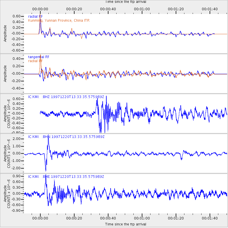
KMI Kunming, Yunnan Province, China - Earthquake Result Viewer
*The percent match for this event was below the threshold and hence no stack was calculated.
| Earthquake location: |
Sea Of Okhotsk |
| Earthquake latitude/longitude: |
53.4/152.8 |
| Earthquake time(UTC): |
1997/12/20 (354) 13:26:31 GMT |
| Earthquake Depth: |
614 km |
| Earthquake Magnitude: |
5.9 UNKNOWN, 5.1 MB, 5.9 MW |
| Earthquake Catalog/Contributor: |
WHDF/NEIC |
|
| Network: |
IC New China Digital Seismograph Network |
| Station: |
KMI Kunming, Yunnan Province, China |
| Lat/Lon: |
25.12 N/102.74 E |
| Elevation: |
1975 m |
|
| Distance: |
46.6 deg |
| Az: |
252.884 deg |
| Baz: |
39.122 deg |
| Ray Param: |
$rayparam |
*The percent match for this event was below the threshold and hence was not used in the summary stack. |
|
| Radial Match: |
73.31785 % |
| Radial Bump: |
387 |
| Transverse Match: |
79.78985 % |
| Transverse Bump: |
400 |
| SOD ConfigId: |
4480 |
| Insert Time: |
2010-03-04 22:36:03.310 +0000 |
| GWidth: |
2.5 |
| Max Bumps: |
400 |
| Tol: |
0.001 |
|
Signal To Noise
| Channel | StoN | STA | LTA |
| IC:KMI: :BHN:19971220T13:33:35.575989Z | 11.764833 | 9.367738E-7 | 7.962491E-8 |
| IC:KMI: :BHE:19971220T13:33:35.575989Z | 6.197789 | 3.3375554E-7 | 5.385074E-8 |
| IC:KMI: :BHZ:19971220T13:33:35.575989Z | 4.13347 | 2.3759905E-7 | 5.7481742E-8 |
| Arrivals |
| Ps | |
| PpPs | |
| PsPs/PpSs | |


