You are here: Home > Network List > IC - New China Digital Seismograph Network Stations List
> Station KMI Kunming, Yunnan Province, China > Earthquake Result Viewer
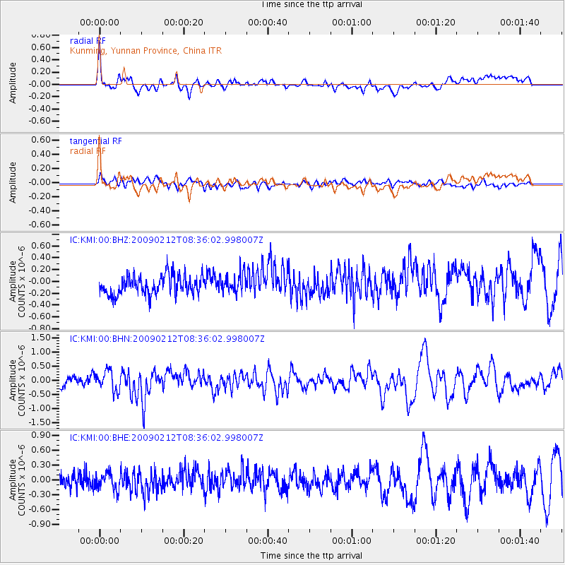
KMI Kunming, Yunnan Province, China - Earthquake Result Viewer
*The percent match for this event was below the threshold and hence no stack was calculated.
| Earthquake location: |
Talaud Islands, Indonesia |
| Earthquake latitude/longitude: |
4.0/126.7 |
| Earthquake time(UTC): |
2009/02/12 (043) 08:30:17 GMT |
| Earthquake Depth: |
35 km |
| Earthquake Magnitude: |
5.9 MB, 6.0 MW, 5.9 MW |
| Earthquake Catalog/Contributor: |
WHDF/NEIC |
|
| Network: |
IC New China Digital Seismograph Network |
| Station: |
KMI Kunming, Yunnan Province, China |
| Lat/Lon: |
25.12 N/102.74 E |
| Elevation: |
1975 m |
|
| Distance: |
31.2 deg |
| Az: |
314.67 deg |
| Baz: |
128.494 deg |
| Ray Param: |
$rayparam |
*The percent match for this event was below the threshold and hence was not used in the summary stack. |
|
| Radial Match: |
71.74361 % |
| Radial Bump: |
400 |
| Transverse Match: |
52.407665 % |
| Transverse Bump: |
400 |
| SOD ConfigId: |
2658 |
| Insert Time: |
2010-03-04 22:36:12.954 +0000 |
| GWidth: |
2.5 |
| Max Bumps: |
400 |
| Tol: |
0.001 |
|
Signal To Noise
| Channel | StoN | STA | LTA |
| IC:KMI:00:BHN:20090212T08:36:02.998007Z | 2.4024553 | 3.5714646E-7 | 1.4865893E-7 |
| IC:KMI:00:BHE:20090212T08:36:02.998007Z | 1.4841613 | 1.7891895E-7 | 1.2055223E-7 |
| IC:KMI:00:BHZ:20090212T08:36:02.998007Z | 0.9999623 | 1.6110951E-7 | 1.611156E-7 |
| Arrivals |
| Ps | |
| PpPs | |
| PsPs/PpSs | |


