You are here: Home > Network List > IC - New China Digital Seismograph Network Stations List
> Station KMI Kunming, Yunnan Province, China > Earthquake Result Viewer
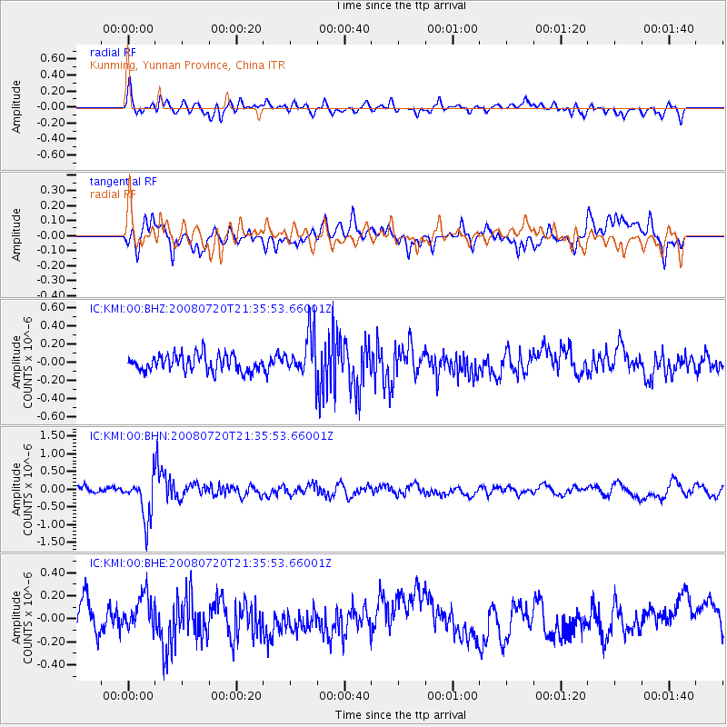
KMI Kunming, Yunnan Province, China - Earthquake Result Viewer
*The percent match for this event was below the threshold and hence no stack was calculated.
| Earthquake location: |
Bonin Islands, Japan Region |
| Earthquake latitude/longitude: |
27.8/139.6 |
| Earthquake time(UTC): |
2008/07/20 (202) 21:30:29 GMT |
| Earthquake Depth: |
481 km |
| Earthquake Magnitude: |
5.8 MW, 5.1 MB, 5.8 MW |
| Earthquake Catalog/Contributor: |
WHDF/NEIC |
|
| Network: |
IC New China Digital Seismograph Network |
| Station: |
KMI Kunming, Yunnan Province, China |
| Lat/Lon: |
25.12 N/102.74 E |
| Elevation: |
1975 m |
|
| Distance: |
33.0 deg |
| Az: |
273.998 deg |
| Baz: |
77.191 deg |
| Ray Param: |
$rayparam |
*The percent match for this event was below the threshold and hence was not used in the summary stack. |
|
| Radial Match: |
64.90665 % |
| Radial Bump: |
400 |
| Transverse Match: |
60.997158 % |
| Transverse Bump: |
400 |
| SOD ConfigId: |
2504 |
| Insert Time: |
2010-03-04 22:36:33.129 +0000 |
| GWidth: |
2.5 |
| Max Bumps: |
400 |
| Tol: |
0.001 |
|
Signal To Noise
| Channel | StoN | STA | LTA |
| IC:KMI:00:BHN:20080720T21:35:53.66001Z | 8.494007 | 6.0212136E-7 | 7.0887786E-8 |
| IC:KMI:00:BHE:20080720T21:35:53.66001Z | 1.5540427 | 1.6040974E-7 | 1.0322094E-7 |
| IC:KMI:00:BHZ:20080720T21:35:53.66001Z | 2.6876519 | 2.448343E-7 | 9.1095984E-8 |
| Arrivals |
| Ps | |
| PpPs | |
| PsPs/PpSs | |


