You are here: Home > Network List > AK - Alaska Regional Network Stations List
> Station DHY Denali Highway > Earthquake Result Viewer
DHY Denali Highway - Earthquake Result Viewer
| Earthquake location: |
Tajikistan |
| Earthquake latitude/longitude: |
38.3/72.7 |
| Earthquake time(UTC): |
2015/12/07 (341) 07:50:07 GMT |
| Earthquake Depth: |
29 km |
| Earthquake Magnitude: |
7.2 MWB |
| Earthquake Catalog/Contributor: |
NEIC PDE/NEIC COMCAT |
|
| Network: |
AK Alaska Regional Network |
| Station: |
DHY Denali Highway |
| Lat/Lon: |
63.08 N/147.38 W |
| Elevation: |
1609 m |
|
| Distance: |
74.0 deg |
| Az: |
17.755 deg |
| Baz: |
328.176 deg |
| Ray Param: |
0.052561723 |
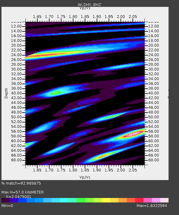
| Estimated Moho Depth: |
57.0 km |
| Estimated Crust Vp/Vs: |
2.05 |
| Assumed Crust Vp: |
6.566 km/s |
| Estimated Crust Vs: |
3.207 km/s |
| Estimated Crust Poisson's Ratio: |
0.34 |
|
| Radial Match: |
92.965675 % |
| Radial Bump: |
339 |
| Transverse Match: |
80.14396 % |
| Transverse Bump: |
400 |
| SOD ConfigId: |
7422571 |
| Insert Time: |
2019-04-21 13:30:58.781 +0000 |
| GWidth: |
2.5 |
| Max Bumps: |
400 |
| Tol: |
0.001 |
|

Signal To Noise
| Channel | StoN | STA | LTA |
| AK:DHY: :BHZ:20151207T08:01:08.968Z | 3.1766925 | 7.449647E-7 | 2.3450956E-7 |
| AK:DHY: :BHN:20151207T08:01:08.968Z | 0.9194761 | 4.609119E-7 | 5.0127665E-7 |
| AK:DHY: :BHE:20151207T08:01:08.968Z | 0.5483731 | 2.0812514E-7 | 3.79532E-7 |
| Arrivals |
| Ps | 9.4 SECOND |
| PpPs | 26 SECOND |
| PsPs/PpSs | 35 SECOND |


