You are here: Home > Network List > IC - New China Digital Seismograph Network Stations List
> Station KMI Kunming, Yunnan Province, China > Earthquake Result Viewer
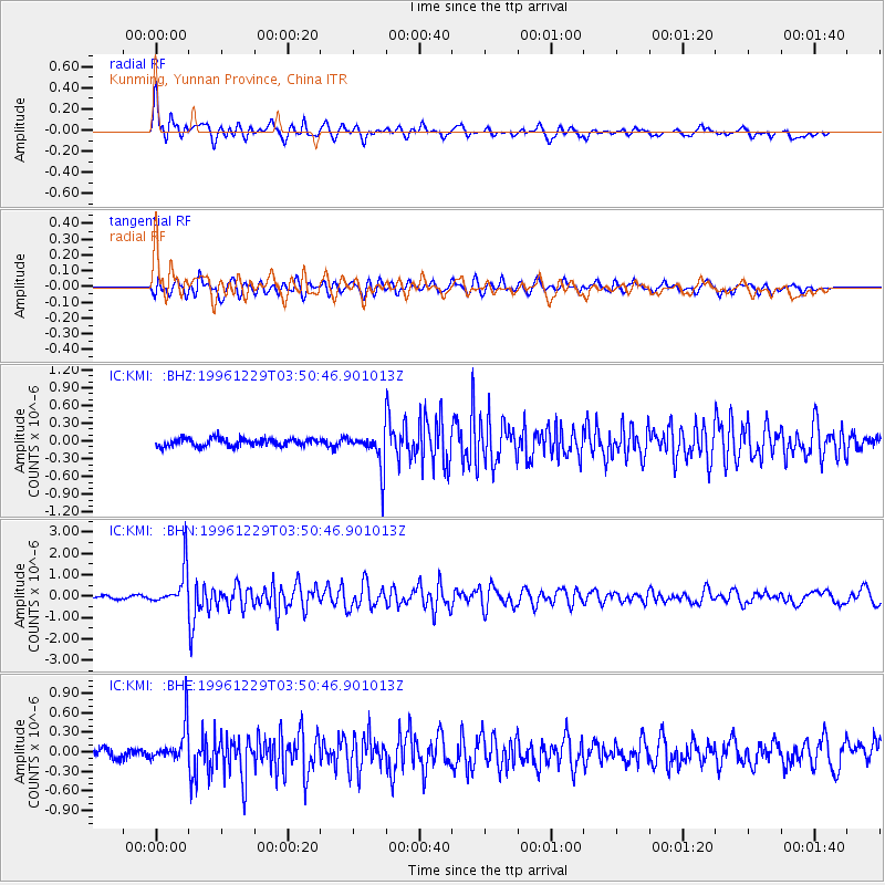
KMI Kunming, Yunnan Province, China - Earthquake Result Viewer
*The percent match for this event was below the threshold and hence no stack was calculated.
| Earthquake location: |
Tanimbar Islands Reg., Indonesia |
| Earthquake latitude/longitude: |
-6.9/131.1 |
| Earthquake time(UTC): |
1996/12/29 (364) 03:43:28 GMT |
| Earthquake Depth: |
31 km |
| Earthquake Magnitude: |
5.8 MB, 5.3 MS, 5.8 UNKNOWN, 5.8 MW |
| Earthquake Catalog/Contributor: |
WHDF/NEIC |
|
| Network: |
IC New China Digital Seismograph Network |
| Station: |
KMI Kunming, Yunnan Province, China |
| Lat/Lon: |
25.12 N/102.74 E |
| Elevation: |
1975 m |
|
| Distance: |
42.1 deg |
| Az: |
320.09 deg |
| Baz: |
135.354 deg |
| Ray Param: |
$rayparam |
*The percent match for this event was below the threshold and hence was not used in the summary stack. |
|
| Radial Match: |
79.47965 % |
| Radial Bump: |
400 |
| Transverse Match: |
78.34918 % |
| Transverse Bump: |
400 |
| SOD ConfigId: |
4480 |
| Insert Time: |
2010-03-04 22:37:05.533 +0000 |
| GWidth: |
2.5 |
| Max Bumps: |
400 |
| Tol: |
0.001 |
|
Signal To Noise
| Channel | StoN | STA | LTA |
| IC:KMI: :BHN:19961229T03:50:46.901013Z | 12.177961 | 8.9003544E-7 | 7.308575E-8 |
| IC:KMI: :BHE:19961229T03:50:46.901013Z | 4.3766828 | 2.9171582E-7 | 6.665227E-8 |
| IC:KMI: :BHZ:19961229T03:50:46.901013Z | 4.7424974 | 3.059709E-7 | 6.451683E-8 |
| Arrivals |
| Ps | |
| PpPs | |
| PsPs/PpSs | |


