You are here: Home > Network List > CB - China National Seismic Network Stations List
> Station WHN Wuhantai,Hubei Province > Earthquake Result Viewer
WHN Wuhantai,Hubei Province - Earthquake Result Viewer
| Earthquake location: |
Tajikistan |
| Earthquake latitude/longitude: |
38.3/72.7 |
| Earthquake time(UTC): |
2015/12/07 (341) 07:50:07 GMT |
| Earthquake Depth: |
29 km |
| Earthquake Magnitude: |
7.2 MWB |
| Earthquake Catalog/Contributor: |
NEIC PDE/NEIC COMCAT |
|
| Network: |
CB China National Seismic Network |
| Station: |
WHN Wuhantai,Hubei Province |
| Lat/Lon: |
30.54 N/114.35 E |
| Elevation: |
80 m |
|
| Distance: |
35.0 deg |
| Az: |
89.96 deg |
| Baz: |
294.156 deg |
| Ray Param: |
0.077417396 |
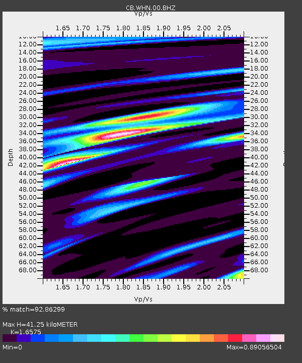
| Estimated Moho Depth: |
41.25 km |
| Estimated Crust Vp/Vs: |
1.66 |
| Assumed Crust Vp: |
6.276 km/s |
| Estimated Crust Vs: |
3.786 km/s |
| Estimated Crust Poisson's Ratio: |
0.21 |
|
| Radial Match: |
92.86299 % |
| Radial Bump: |
329 |
| Transverse Match: |
77.64833 % |
| Transverse Bump: |
400 |
| SOD ConfigId: |
7422571 |
| Insert Time: |
2019-04-21 13:32:07.807 +0000 |
| GWidth: |
2.5 |
| Max Bumps: |
400 |
| Tol: |
0.001 |
|

Signal To Noise
| Channel | StoN | STA | LTA |
| CB:WHN:00:BHZ:20151207T07:56:25.349989Z | 6.1276407 | 1.8505774E-6 | 3.0200488E-7 |
| CB:WHN:00:BHN:20151207T07:56:25.349989Z | 1.0361755 | 3.2672295E-7 | 3.1531624E-7 |
| CB:WHN:00:BHE:20151207T07:56:25.349989Z | 2.8232791 | 8.266963E-7 | 2.9281424E-7 |
| Arrivals |
| Ps | 4.7 SECOND |
| PpPs | 16 SECOND |
| PsPs/PpSs | 21 SECOND |


