You are here: Home > Network List > IC - New China Digital Seismograph Network Stations List
> Station KMI Kunming, Yunnan Province, China > Earthquake Result Viewer
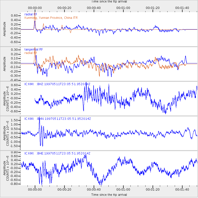
KMI Kunming, Yunnan Province, China - Earthquake Result Viewer
*The percent match for this event was below the threshold and hence no stack was calculated.
| Earthquake location: |
Eastern Honshu, Japan |
| Earthquake latitude/longitude: |
37.1/140.9 |
| Earthquake time(UTC): |
1997/05/11 (131) 22:59:38 GMT |
| Earthquake Depth: |
49 km |
| Earthquake Magnitude: |
5.5 MB, 5.3 MS |
| Earthquake Catalog/Contributor: |
WHDF/NEIC |
|
| Network: |
IC New China Digital Seismograph Network |
| Station: |
KMI Kunming, Yunnan Province, China |
| Lat/Lon: |
25.12 N/102.74 E |
| Elevation: |
1975 m |
|
| Distance: |
34.6 deg |
| Az: |
260.843 deg |
| Baz: |
60.56 deg |
| Ray Param: |
$rayparam |
*The percent match for this event was below the threshold and hence was not used in the summary stack. |
|
| Radial Match: |
65.60441 % |
| Radial Bump: |
394 |
| Transverse Match: |
53.161057 % |
| Transverse Bump: |
371 |
| SOD ConfigId: |
4480 |
| Insert Time: |
2010-03-04 22:37:16.867 +0000 |
| GWidth: |
2.5 |
| Max Bumps: |
400 |
| Tol: |
0.001 |
|
Signal To Noise
| Channel | StoN | STA | LTA |
| IC:KMI: :BHN:19970511T23:05:51.952014Z | 5.5752025 | 6.6089433E-7 | 1.1854176E-7 |
| IC:KMI: :BHE:19970511T23:05:51.952014Z | 2.7886713 | 3.5204792E-7 | 1.2624217E-7 |
| IC:KMI: :BHZ:19970511T23:05:51.952014Z | 2.7890565 | 3.243009E-7 | 1.1627621E-7 |
| Arrivals |
| Ps | |
| PpPs | |
| PsPs/PpSs | |


