You are here: Home > Network List > JP - Japan Meteorological Agency Seismic Network Stations List
> Station JTU Tsushima Kamiagata > Earthquake Result Viewer
JTU Tsushima Kamiagata - Earthquake Result Viewer
| Earthquake location: |
Tajikistan |
| Earthquake latitude/longitude: |
38.3/72.7 |
| Earthquake time(UTC): |
2015/12/07 (341) 07:50:07 GMT |
| Earthquake Depth: |
29 km |
| Earthquake Magnitude: |
7.2 MWB |
| Earthquake Catalog/Contributor: |
NEIC PDE/NEIC COMCAT |
|
| Network: |
JP Japan Meteorological Agency Seismic Network |
| Station: |
JTU Tsushima Kamiagata |
| Lat/Lon: |
34.53 N/129.40 E |
| Elevation: |
70 m |
|
| Distance: |
45.2 deg |
| Az: |
76.593 deg |
| Baz: |
291.957 deg |
| Ray Param: |
0.07139943 |
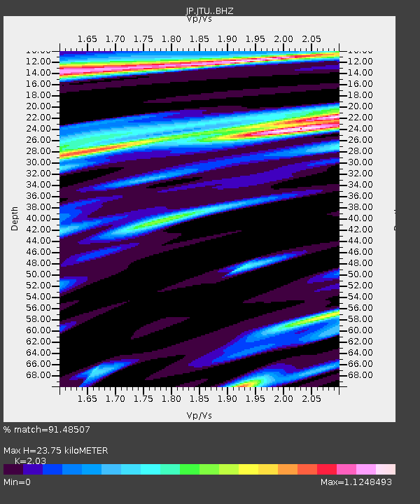
| Estimated Moho Depth: |
23.75 km |
| Estimated Crust Vp/Vs: |
2.03 |
| Assumed Crust Vp: |
6.472 km/s |
| Estimated Crust Vs: |
3.188 km/s |
| Estimated Crust Poisson's Ratio: |
0.34 |
|
| Radial Match: |
91.48507 % |
| Radial Bump: |
400 |
| Transverse Match: |
99.434746 % |
| Transverse Bump: |
123 |
| SOD ConfigId: |
7422571 |
| Insert Time: |
2019-04-21 13:33:52.710 +0000 |
| GWidth: |
2.5 |
| Max Bumps: |
400 |
| Tol: |
0.001 |
|

Signal To Noise
| Channel | StoN | STA | LTA |
| JP:JTU: :BHZ:20151207T07:57:49.949995Z | 3.0599852 | 6.9373647E-7 | 2.2671236E-7 |
| JP:JTU: :BHN:20151207T07:57:49.949995Z | 3.33013 | 6.282101E-7 | 1.8864432E-7 |
| JP:JTU: :BHE:20151207T07:57:49.949995Z | 0.84644604 | 1.9887845E-7 | 2.3495703E-7 |
| Arrivals |
| Ps | 4.0 SECOND |
| PpPs | 11 SECOND |
| PsPs/PpSs | 15 SECOND |


