You are here: Home > Network List > TA - USArray Transportable Network (new EarthScope stations) Stations List
> Station TCOL CIGO, UAF Yankovich Road, Fairbanks, AK, USA > Earthquake Result Viewer
TCOL CIGO, UAF Yankovich Road, Fairbanks, AK, USA - Earthquake Result Viewer
| Earthquake location: |
Tajikistan |
| Earthquake latitude/longitude: |
38.3/72.7 |
| Earthquake time(UTC): |
2015/12/07 (341) 07:50:07 GMT |
| Earthquake Depth: |
29 km |
| Earthquake Magnitude: |
7.2 MWB |
| Earthquake Catalog/Contributor: |
NEIC PDE/NEIC COMCAT |
|
| Network: |
TA USArray Transportable Network (new EarthScope stations) |
| Station: |
TCOL CIGO, UAF Yankovich Road, Fairbanks, AK, USA |
| Lat/Lon: |
64.87 N/147.86 W |
| Elevation: |
178 m |
|
| Distance: |
72.4 deg |
| Az: |
16.941 deg |
| Baz: |
327.505 deg |
| Ray Param: |
0.0536474 |
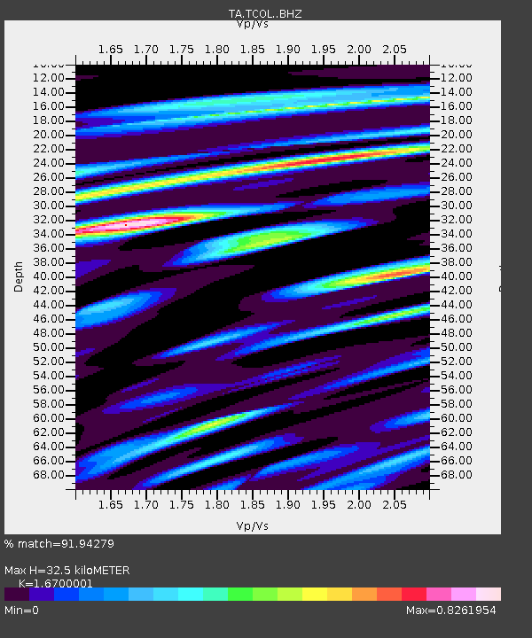
| Estimated Moho Depth: |
32.5 km |
| Estimated Crust Vp/Vs: |
1.67 |
| Assumed Crust Vp: |
6.566 km/s |
| Estimated Crust Vs: |
3.932 km/s |
| Estimated Crust Poisson's Ratio: |
0.22 |
|
| Radial Match: |
91.94279 % |
| Radial Bump: |
400 |
| Transverse Match: |
83.58155 % |
| Transverse Bump: |
400 |
| SOD ConfigId: |
7422571 |
| Insert Time: |
2019-04-21 13:35:55.160 +0000 |
| GWidth: |
2.5 |
| Max Bumps: |
400 |
| Tol: |
0.001 |
|

Signal To Noise
| Channel | StoN | STA | LTA |
| TA:TCOL: :BHZ:20151207T08:00:59.299971Z | 5.9082813 | 1.0277026E-6 | 1.7394274E-7 |
| TA:TCOL: :BHN:20151207T08:00:59.299971Z | 2.4256394 | 3.5202814E-7 | 1.4512798E-7 |
| TA:TCOL: :BHE:20151207T08:00:59.299971Z | 1.1336943 | 3.5019445E-7 | 3.0889674E-7 |
| Arrivals |
| Ps | 3.4 SECOND |
| PpPs | 13 SECOND |
| PsPs/PpSs | 16 SECOND |


