You are here: Home > Network List > IC - New China Digital Seismograph Network Stations List
> Station LSA Tibet, China > Earthquake Result Viewer
LSA Tibet, China - Earthquake Result Viewer
| Earthquake location: |
Sumba Region, Indonesia |
| Earthquake latitude/longitude: |
-10.0/119.4 |
| Earthquake time(UTC): |
2000/10/07 (281) 11:57:40 GMT |
| Earthquake Depth: |
33 km |
| Earthquake Magnitude: |
5.8 MB, 5.6 MS, 5.9 MW, 5.8 MW |
| Earthquake Catalog/Contributor: |
WHDF/NEIC |
|
| Network: |
IC New China Digital Seismograph Network |
| Station: |
LSA Tibet, China |
| Lat/Lon: |
29.70 N/91.15 E |
| Elevation: |
3789 m |
|
| Distance: |
47.9 deg |
| Az: |
326.32 deg |
| Baz: |
141.106 deg |
| Ray Param: |
0.06963132 |
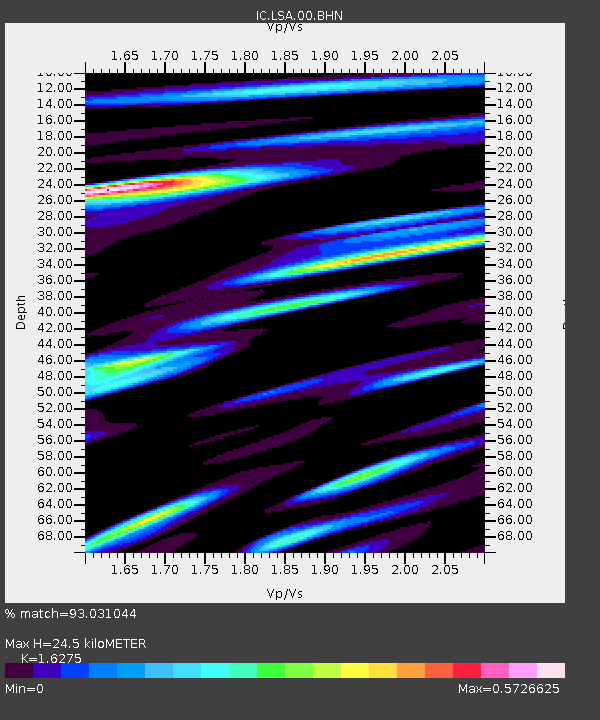
| Estimated Moho Depth: |
24.5 km |
| Estimated Crust Vp/Vs: |
1.63 |
| Assumed Crust Vp: |
6.514 km/s |
| Estimated Crust Vs: |
4.003 km/s |
| Estimated Crust Poisson's Ratio: |
0.20 |
|
| Radial Match: |
93.031044 % |
| Radial Bump: |
400 |
| Transverse Match: |
83.41631 % |
| Transverse Bump: |
400 |
| SOD ConfigId: |
3753 |
| Insert Time: |
2010-03-04 22:37:34.755 +0000 |
| GWidth: |
2.5 |
| Max Bumps: |
400 |
| Tol: |
0.001 |
|
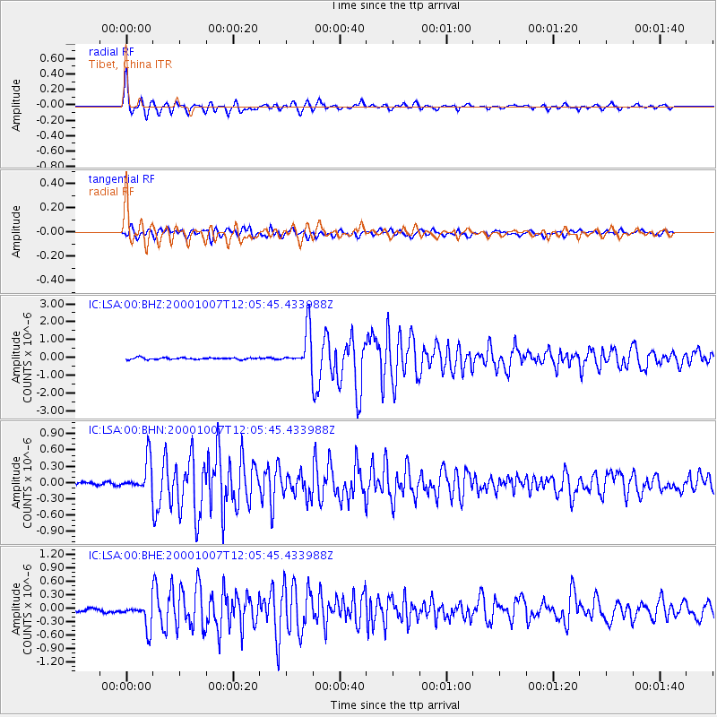
Signal To Noise
| Channel | StoN | STA | LTA |
| IC:LSA:00:BHN:20001007T12:05:45.433988Z | 14.6757145 | 3.020286E-7 | 2.0580163E-8 |
| IC:LSA:00:BHE:20001007T12:05:45.433988Z | 7.78191 | 2.962347E-7 | 3.8067096E-8 |
| IC:LSA:00:BHZ:20001007T12:05:45.433988Z | 21.496922 | 1.0891848E-6 | 5.0667015E-8 |
| Arrivals |
| Ps | 2.5 SECOND |
| PpPs | 9.2 SECOND |
| PsPs/PpSs | 12 SECOND |


