You are here: Home > Network List > IC - New China Digital Seismograph Network Stations List
> Station LSA Tibet, China > Earthquake Result Viewer
LSA Tibet, China - Earthquake Result Viewer
| Earthquake location: |
South Indian Ocean |
| Earthquake latitude/longitude: |
-39.8/41.8 |
| Earthquake time(UTC): |
2000/09/08 (252) 01:34:41 GMT |
| Earthquake Depth: |
10 km |
| Earthquake Magnitude: |
5.6 MB, 5.7 MS, 5.9 MW, 5.8 MW |
| Earthquake Catalog/Contributor: |
WHDF/NEIC |
|
| Network: |
IC New China Digital Seismograph Network |
| Station: |
LSA Tibet, China |
| Lat/Lon: |
29.70 N/91.15 E |
| Elevation: |
3789 m |
|
| Distance: |
83.0 deg |
| Az: |
41.715 deg |
| Baz: |
216.075 deg |
| Ray Param: |
0.046481624 |
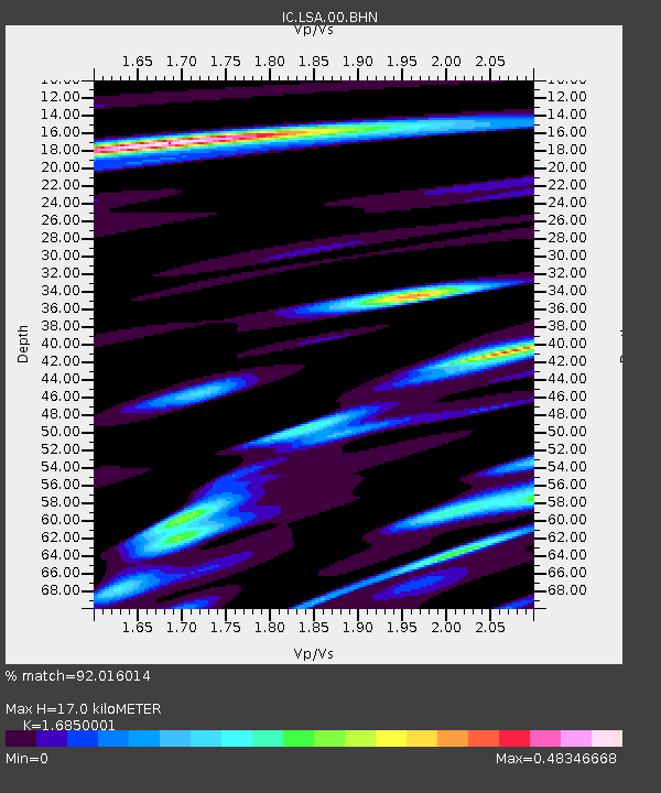
| Estimated Moho Depth: |
17.0 km |
| Estimated Crust Vp/Vs: |
1.69 |
| Assumed Crust Vp: |
6.514 km/s |
| Estimated Crust Vs: |
3.866 km/s |
| Estimated Crust Poisson's Ratio: |
0.23 |
|
| Radial Match: |
92.016014 % |
| Radial Bump: |
400 |
| Transverse Match: |
79.680534 % |
| Transverse Bump: |
400 |
| SOD ConfigId: |
3753 |
| Insert Time: |
2010-03-04 22:37:36.798 +0000 |
| GWidth: |
2.5 |
| Max Bumps: |
400 |
| Tol: |
0.001 |
|

Signal To Noise
| Channel | StoN | STA | LTA |
| IC:LSA:00:BHN:20000908T01:46:35.412017Z | 2.102163 | 5.552489E-8 | 2.6413217E-8 |
| IC:LSA:00:BHE:20000908T01:46:35.412017Z | 1.4722584 | 4.815204E-8 | 3.270624E-8 |
| IC:LSA:00:BHZ:20000908T01:46:35.412017Z | 6.241183 | 3.8998004E-7 | 6.248496E-8 |
| Arrivals |
| Ps | 1.8 SECOND |
| PpPs | 6.8 SECOND |
| PsPs/PpSs | 8.7 SECOND |


