You are here: Home > Network List > IC - New China Digital Seismograph Network Stations List
> Station LSA Tibet, China > Earthquake Result Viewer
LSA Tibet, China - Earthquake Result Viewer
| Earthquake location: |
Banda Sea |
| Earthquake latitude/longitude: |
-7.0/128.9 |
| Earthquake time(UTC): |
2000/07/15 (197) 07:13:44 GMT |
| Earthquake Depth: |
218 km |
| Earthquake Magnitude: |
5.6 MB, 5.9 MW, 5.9 MW |
| Earthquake Catalog/Contributor: |
WHDF/NEIC |
|
| Network: |
IC New China Digital Seismograph Network |
| Station: |
LSA Tibet, China |
| Lat/Lon: |
29.70 N/91.15 E |
| Elevation: |
3789 m |
|
| Distance: |
51.5 deg |
| Az: |
317.063 deg |
| Baz: |
129.001 deg |
| Ray Param: |
0.06658913 |
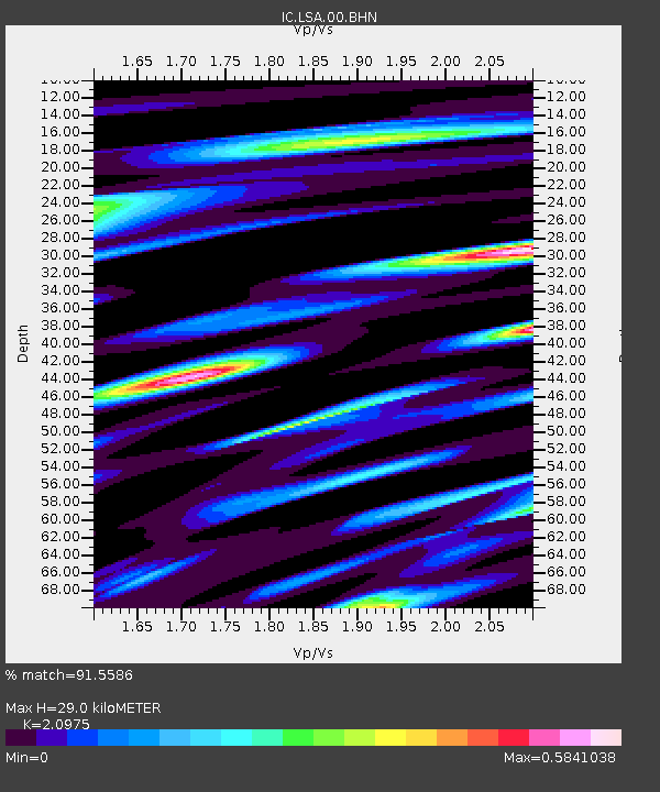
| Estimated Moho Depth: |
29.0 km |
| Estimated Crust Vp/Vs: |
2.10 |
| Assumed Crust Vp: |
6.514 km/s |
| Estimated Crust Vs: |
3.106 km/s |
| Estimated Crust Poisson's Ratio: |
0.35 |
|
| Radial Match: |
91.5586 % |
| Radial Bump: |
315 |
| Transverse Match: |
82.22487 % |
| Transverse Bump: |
400 |
| SOD ConfigId: |
3753 |
| Insert Time: |
2010-03-04 22:37:42.636 +0000 |
| GWidth: |
2.5 |
| Max Bumps: |
400 |
| Tol: |
0.001 |
|
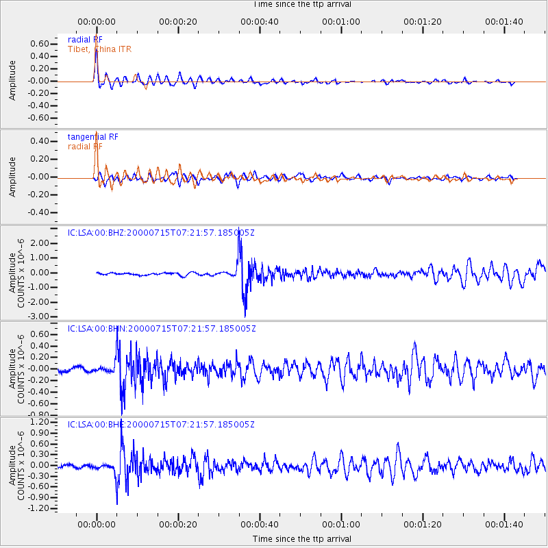
Signal To Noise
| Channel | StoN | STA | LTA |
| IC:LSA:00:BHN:20000715T07:21:57.185005Z | 3.4415386 | 9.918319E-8 | 2.8819432E-8 |
| IC:LSA:00:BHE:20000715T07:21:57.185005Z | 2.9825618 | 1.4649059E-7 | 4.911569E-8 |
| IC:LSA:00:BHZ:20000715T07:21:57.185005Z | 5.7890377 | 4.712864E-7 | 8.141014E-8 |
| Arrivals |
| Ps | 5.1 SECOND |
| PpPs | 13 SECOND |
| PsPs/PpSs | 18 SECOND |


