You are here: Home > Network List > IC - New China Digital Seismograph Network Stations List
> Station LSA Tibet, China > Earthquake Result Viewer
LSA Tibet, China - Earthquake Result Viewer
| Earthquake location: |
Flores Sea |
| Earthquake latitude/longitude: |
-8.0/120.6 |
| Earthquake time(UTC): |
2000/01/23 (023) 06:08:24 GMT |
| Earthquake Depth: |
47 km |
| Earthquake Magnitude: |
5.7 MB, 5.2 MS, 5.8 MW, 5.7 MW |
| Earthquake Catalog/Contributor: |
WHDF/NEIC |
|
| Network: |
IC New China Digital Seismograph Network |
| Station: |
LSA Tibet, China |
| Lat/Lon: |
29.70 N/91.15 E |
| Elevation: |
3789 m |
|
| Distance: |
47.0 deg |
| Az: |
324.163 deg |
| Baz: |
138.202 deg |
| Ray Param: |
0.07018246 |
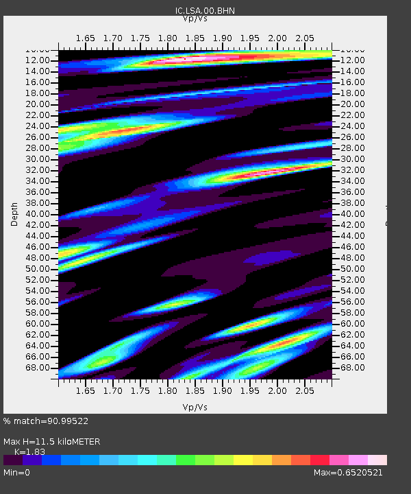
| Estimated Moho Depth: |
11.5 km |
| Estimated Crust Vp/Vs: |
1.83 |
| Assumed Crust Vp: |
6.514 km/s |
| Estimated Crust Vs: |
3.56 km/s |
| Estimated Crust Poisson's Ratio: |
0.29 |
|
| Radial Match: |
90.99522 % |
| Radial Bump: |
400 |
| Transverse Match: |
84.44853 % |
| Transverse Bump: |
400 |
| SOD ConfigId: |
3753 |
| Insert Time: |
2010-03-04 22:37:47.858 +0000 |
| GWidth: |
2.5 |
| Max Bumps: |
400 |
| Tol: |
0.001 |
|
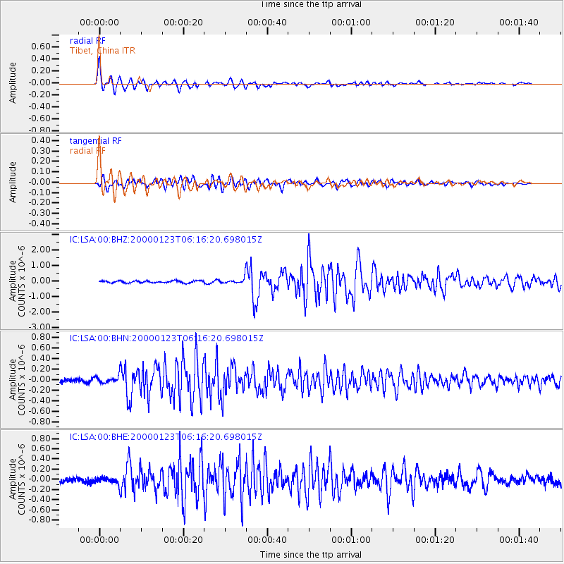
Signal To Noise
| Channel | StoN | STA | LTA |
| IC:LSA:00:BHN:20000123T06:16:20.698015Z | 2.3668368 | 6.590473E-8 | 2.7845065E-8 |
| IC:LSA:00:BHE:20000123T06:16:20.698015Z | 1.317734 | 6.425129E-8 | 4.8758924E-8 |
| IC:LSA:00:BHZ:20000123T06:16:20.698015Z | 2.9368412 | 1.9106304E-7 | 6.505733E-8 |
| Arrivals |
| Ps | 1.6 SECOND |
| PpPs | 4.7 SECOND |
| PsPs/PpSs | 6.3 SECOND |


