You are here: Home > Network List > TA - USArray Transportable Network (new EarthScope stations) Stations List
> Station X43A Marvell, AR, USA > Earthquake Result Viewer
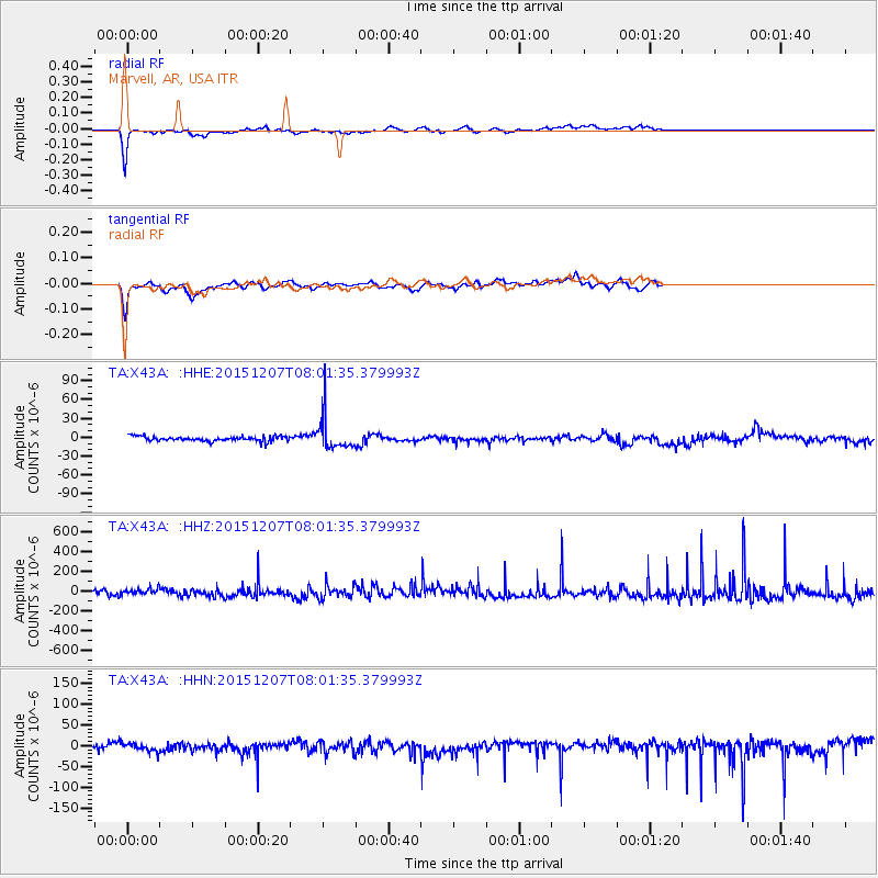
X43A Marvell, AR, USA - Earthquake Result Viewer
*The percent match for this event was below the threshold and hence no stack was calculated.
| Earthquake location: |
Near Coast Of Central Chile |
| Earthquake latitude/longitude: |
-31.4/-71.4 |
| Earthquake time(UTC): |
2015/12/07 (341) 07:51:11 GMT |
| Earthquake Depth: |
48 km |
| Earthquake Magnitude: |
5.6 MB |
| Earthquake Catalog/Contributor: |
NEIC PDE/NEIC COMCAT |
|
| Network: |
TA USArray Transportable Network (new EarthScope stations) |
| Station: |
X43A Marvell, AR, USA |
| Lat/Lon: |
34.52 N/90.88 W |
| Elevation: |
53 m |
|
| Distance: |
68.1 deg |
| Az: |
342.712 deg |
| Baz: |
162.073 deg |
| Ray Param: |
$rayparam |
*The percent match for this event was below the threshold and hence was not used in the summary stack. |
|
| Radial Match: |
81.295135 % |
| Radial Bump: |
293 |
| Transverse Match: |
75.68627 % |
| Transverse Bump: |
336 |
| SOD ConfigId: |
7422571 |
| Insert Time: |
2019-04-21 13:43:01.471 +0000 |
| GWidth: |
2.5 |
| Max Bumps: |
400 |
| Tol: |
0.001 |
|
Signal To Noise
| Channel | StoN | STA | LTA |
| TA:X43A: :HHZ:20151207T08:01:35.379993Z | 0.60332066 | 3.054178E-5 | 5.0622806E-5 |
| TA:X43A: :HHN:20151207T08:01:35.379993Z | 0.77076083 | 8.857132E-6 | 1.1491415E-5 |
| TA:X43A: :HHE:20151207T08:01:35.379993Z | 6.5634303 | 2.5557956E-5 | 3.893994E-6 |
| Arrivals |
| Ps | |
| PpPs | |
| PsPs/PpSs | |


