You are here: Home > Network List > IC - New China Digital Seismograph Network Stations List
> Station LSA Tibet, China > Earthquake Result Viewer
LSA Tibet, China - Earthquake Result Viewer
| Earthquake location: |
Banda Sea |
| Earthquake latitude/longitude: |
-4.2/127.3 |
| Earthquake time(UTC): |
2000/08/28 (241) 19:29:24 GMT |
| Earthquake Depth: |
33 km |
| Earthquake Magnitude: |
6.0 MB |
| Earthquake Catalog/Contributor: |
WHDF/NEIC |
|
| Network: |
IC New China Digital Seismograph Network |
| Station: |
LSA Tibet, China |
| Lat/Lon: |
29.70 N/91.15 E |
| Elevation: |
3789 m |
|
| Distance: |
48.3 deg |
| Az: |
316.57 deg |
| Baz: |
127.993 deg |
| Ray Param: |
0.06938024 |
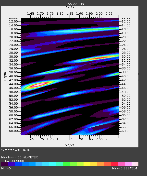
| Estimated Moho Depth: |
44.25 km |
| Estimated Crust Vp/Vs: |
1.69 |
| Assumed Crust Vp: |
6.514 km/s |
| Estimated Crust Vs: |
3.866 km/s |
| Estimated Crust Poisson's Ratio: |
0.23 |
|
| Radial Match: |
91.84948 % |
| Radial Bump: |
400 |
| Transverse Match: |
84.35168 % |
| Transverse Bump: |
400 |
| SOD ConfigId: |
3744 |
| Insert Time: |
2010-03-04 22:38:06.801 +0000 |
| GWidth: |
2.5 |
| Max Bumps: |
400 |
| Tol: |
0.001 |
|
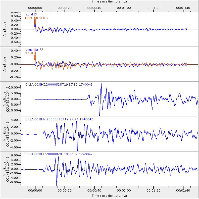
Signal To Noise
| Channel | StoN | STA | LTA |
| IC:LSA:00:BHN:20000828T19:37:32.174004Z | 1.2701474 | 3.0709344E-8 | 2.4177778E-8 |
| IC:LSA:00:BHE:20000828T19:37:32.174004Z | 1.1594332 | 5.1288893E-8 | 4.4236174E-8 |
| IC:LSA:00:BHZ:20000828T19:37:32.174004Z | 0.6201281 | 4.6065963E-8 | 7.428459E-8 |
| Arrivals |
| Ps | 5.0 SECOND |
| PpPs | 17 SECOND |
| PsPs/PpSs | 22 SECOND |


