You are here: Home > Network List > N4 - Central and EAstern US Network Stations List
> Station J61A Chester > Earthquake Result Viewer
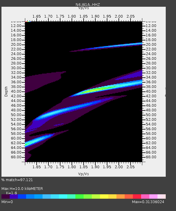
J61A Chester - Earthquake Result Viewer
| Earthquake location: |
Kyrgyzstan |
| Earthquake latitude/longitude: |
41.7/74.7 |
| Earthquake time(UTC): |
2015/12/07 (341) 08:30:57 GMT |
| Earthquake Depth: |
26 km |
| Earthquake Magnitude: |
5.5 MB |
| Earthquake Catalog/Contributor: |
NEIC PDE/NEIC COMCAT |
|
| Network: |
N4 Central and EAstern US Network |
| Station: |
J61A Chester |
| Lat/Lon: |
43.35 N/72.55 W |
| Elevation: |
253 m |
|
| Distance: |
90.4 deg |
| Az: |
336.727 deg |
| Baz: |
23.935 deg |
| Ray Param: |
0.04167636 |
| Estimated Moho Depth: |
10.0 km |
| Estimated Crust Vp/Vs: |
1.60 |
| Assumed Crust Vp: |
6.419 km/s |
| Estimated Crust Vs: |
4.012 km/s |
| Estimated Crust Poisson's Ratio: |
0.18 |
|
| Radial Match: |
97.121 % |
| Radial Bump: |
301 |
| Transverse Match: |
53.890316 % |
| Transverse Bump: |
376 |
| SOD ConfigId: |
7422571 |
| Insert Time: |
2019-04-21 13:47:35.978 +0000 |
| GWidth: |
2.5 |
| Max Bumps: |
400 |
| Tol: |
0.001 |
|

Signal To Noise
| Channel | StoN | STA | LTA |
| N4:J61A: :HHZ:20151207T08:43:24.370012Z | 1.7988912 | 5.5546592E-5 | 3.087824E-5 |
| N4:J61A: :HHN:20151207T08:43:24.370012Z | 4.413116 | 3.662011E-5 | 8.298016E-6 |
| N4:J61A: :HHE:20151207T08:43:24.370012Z | 0.32069513 | 9.703138E-6 | 3.0256582E-5 |
| Arrivals |
| Ps | 1.0 SECOND |
| PpPs | 4.0 SECOND |
| PsPs/PpSs | 4.9 SECOND |


