You are here: Home > Network List > CI - Caltech Regional Seismic Network Stations List
> Station VES Vestal, Porterville, CA, USA > Earthquake Result Viewer
VES Vestal, Porterville, CA, USA - Earthquake Result Viewer
| Earthquake location: |
East Of Kuril Islands |
| Earthquake latitude/longitude: |
46.7/155.3 |
| Earthquake time(UTC): |
2006/11/15 (319) 11:34:58 GMT |
| Earthquake Depth: |
10 km |
| Earthquake Magnitude: |
6.4 MB |
| Earthquake Catalog/Contributor: |
WHDF/NEIC |
|
| Network: |
CI Caltech Regional Seismic Network |
| Station: |
VES Vestal, Porterville, CA, USA |
| Lat/Lon: |
35.84 N/119.08 W |
| Elevation: |
154 m |
|
| Distance: |
62.3 deg |
| Az: |
66.248 deg |
| Baz: |
309.103 deg |
| Ray Param: |
0.060342208 |
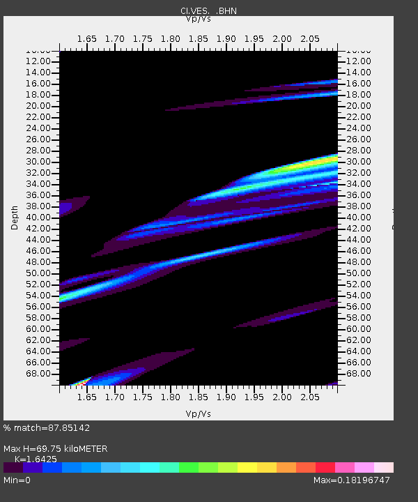
| Estimated Moho Depth: |
69.75 km |
| Estimated Crust Vp/Vs: |
1.64 |
| Assumed Crust Vp: |
6.1 km/s |
| Estimated Crust Vs: |
3.714 km/s |
| Estimated Crust Poisson's Ratio: |
0.21 |
|
| Radial Match: |
87.85142 % |
| Radial Bump: |
400 |
| Transverse Match: |
72.26923 % |
| Transverse Bump: |
382 |
| SOD ConfigId: |
2564 |
| Insert Time: |
2010-02-26 00:00:15.423 +0000 |
| GWidth: |
2.5 |
| Max Bumps: |
400 |
| Tol: |
0.001 |
|
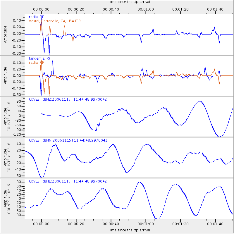
Signal To Noise
| Channel | StoN | STA | LTA |
| CI:VES: :BHN:20061115T11:44:48.997004Z | 2.4293 | 5.5284196E-5 | 2.2757255E-5 |
| CI:VES: :BHE:20061115T11:44:48.997004Z | 1.0007248 | 3.0469953E-5 | 3.0447884E-5 |
| CI:VES: :BHZ:20061115T11:44:48.997004Z | 8.84979 | 7.901056E-5 | 8.927959E-6 |
| Arrivals |
| Ps | 7.7 SECOND |
| PpPs | 29 SECOND |
| PsPs/PpSs | 37 SECOND |


