You are here: Home > Network List > TA - USArray Transportable Network (new EarthScope stations) Stations List
> Station D04E Lakebay, WA, USA > Earthquake Result Viewer
D04E Lakebay, WA, USA - Earthquake Result Viewer
| Earthquake location: |
Kyrgyzstan |
| Earthquake latitude/longitude: |
41.7/74.7 |
| Earthquake time(UTC): |
2015/12/07 (341) 08:30:57 GMT |
| Earthquake Depth: |
26 km |
| Earthquake Magnitude: |
5.5 MB |
| Earthquake Catalog/Contributor: |
NEIC PDE/NEIC COMCAT |
|
| Network: |
TA USArray Transportable Network (new EarthScope stations) |
| Station: |
D04E Lakebay, WA, USA |
| Lat/Lon: |
47.18 N/122.77 W |
| Elevation: |
45 m |
|
| Distance: |
90.2 deg |
| Az: |
11.788 deg |
| Baz: |
347.037 deg |
| Ray Param: |
0.041689117 |
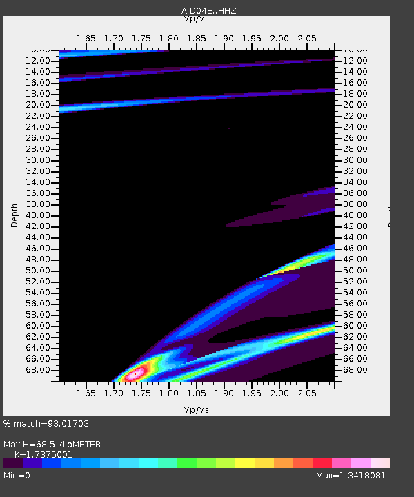
| Estimated Moho Depth: |
68.5 km |
| Estimated Crust Vp/Vs: |
1.74 |
| Assumed Crust Vp: |
6.566 km/s |
| Estimated Crust Vs: |
3.779 km/s |
| Estimated Crust Poisson's Ratio: |
0.25 |
|
| Radial Match: |
93.01703 % |
| Radial Bump: |
400 |
| Transverse Match: |
79.281944 % |
| Transverse Bump: |
400 |
| SOD ConfigId: |
7422571 |
| Insert Time: |
2019-04-21 13:48:35.819 +0000 |
| GWidth: |
2.5 |
| Max Bumps: |
400 |
| Tol: |
0.001 |
|

Signal To Noise
| Channel | StoN | STA | LTA |
| TA:D04E: :HHZ:20151207T08:43:23.630022Z | 1.698198 | 6.7166264E-5 | 3.9551494E-5 |
| TA:D04E: :HHN:20151207T08:43:23.630022Z | 0.827367 | 5.409879E-5 | 6.538669E-5 |
| TA:D04E: :HHE:20151207T08:43:23.630022Z | 1.8007517 | 3.2897307E-5 | 1.8268653E-5 |
| Arrivals |
| Ps | 7.9 SECOND |
| PpPs | 28 SECOND |
| PsPs/PpSs | 36 SECOND |


