You are here: Home > Network List > TA - USArray Transportable Network (new EarthScope stations) Stations List
> Station J20K Nowitna River, AK, USA > Earthquake Result Viewer
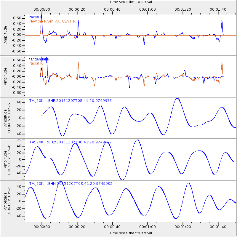
J20K Nowitna River, AK, USA - Earthquake Result Viewer
*The percent match for this event was below the threshold and hence no stack was calculated.
| Earthquake location: |
Kyrgyzstan |
| Earthquake latitude/longitude: |
41.7/74.7 |
| Earthquake time(UTC): |
2015/12/07 (341) 08:30:57 GMT |
| Earthquake Depth: |
26 km |
| Earthquake Magnitude: |
5.5 MB |
| Earthquake Catalog/Contributor: |
NEIC PDE/NEIC COMCAT |
|
| Network: |
TA USArray Transportable Network (new EarthScope stations) |
| Station: |
J20K Nowitna River, AK, USA |
| Lat/Lon: |
64.18 N/154.15 W |
| Elevation: |
314 m |
|
| Distance: |
67.7 deg |
| Az: |
20.866 deg |
| Baz: |
322.47 deg |
| Ray Param: |
$rayparam |
*The percent match for this event was below the threshold and hence was not used in the summary stack. |
|
| Radial Match: |
69.43474 % |
| Radial Bump: |
400 |
| Transverse Match: |
89.88302 % |
| Transverse Bump: |
274 |
| SOD ConfigId: |
7422571 |
| Insert Time: |
2019-04-21 13:48:44.998 +0000 |
| GWidth: |
2.5 |
| Max Bumps: |
400 |
| Tol: |
0.001 |
|
Signal To Noise
| Channel | StoN | STA | LTA |
| TA:J20K: :BHZ:20151207T08:41:20.974993Z | 0.5994963 | 1.9878431E-5 | 3.3158554E-5 |
| TA:J20K: :BHN:20151207T08:41:20.974993Z | 2.4772854 | 4.3368338E-5 | 1.7506396E-5 |
| TA:J20K: :BHE:20151207T08:41:20.974993Z | 0.97971207 | 2.0864965E-5 | 2.1297039E-5 |
| Arrivals |
| Ps | |
| PpPs | |
| PsPs/PpSs | |


