You are here: Home > Network List > US - United States National Seismic Network Stations List
> Station DGMT Dagmar, Montana, USA > Earthquake Result Viewer
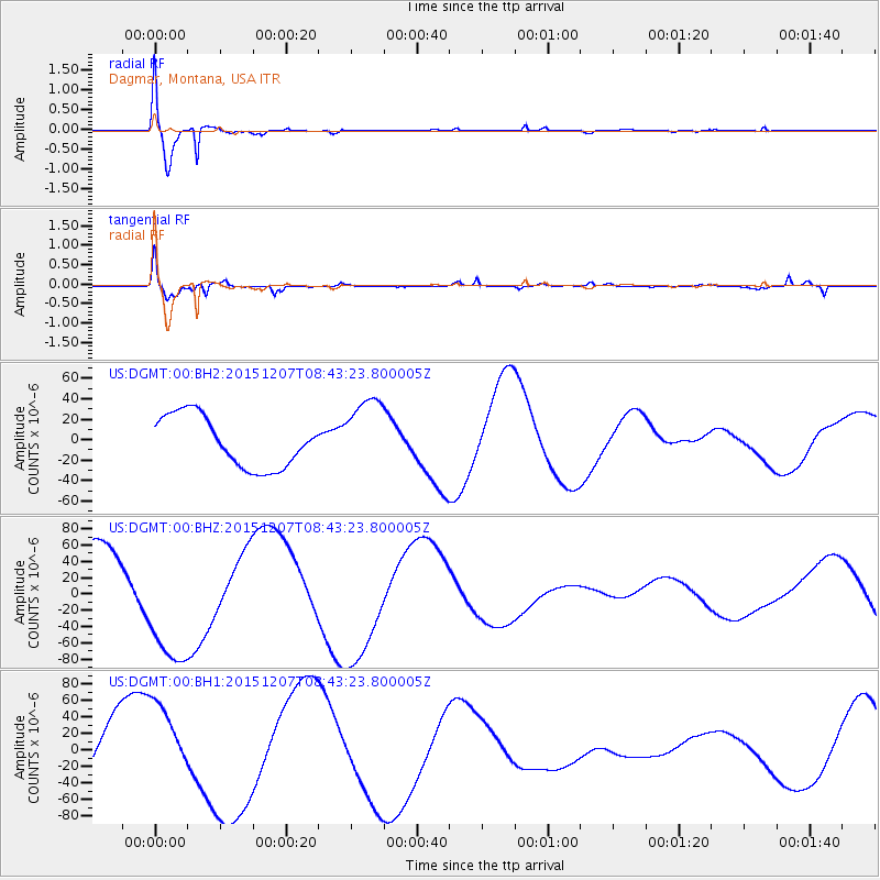
DGMT Dagmar, Montana, USA - Earthquake Result Viewer
*The percent match for this event was below the threshold and hence no stack was calculated.
| Earthquake location: |
Kyrgyzstan |
| Earthquake latitude/longitude: |
41.7/74.7 |
| Earthquake time(UTC): |
2015/12/07 (341) 08:30:57 GMT |
| Earthquake Depth: |
26 km |
| Earthquake Magnitude: |
5.5 MB |
| Earthquake Catalog/Contributor: |
NEIC PDE/NEIC COMCAT |
|
| Network: |
US United States National Seismic Network |
| Station: |
DGMT Dagmar, Montana, USA |
| Lat/Lon: |
48.47 N/104.20 W |
| Elevation: |
0.0 m |
|
| Distance: |
90.2 deg |
| Az: |
359.234 deg |
| Baz: |
0.862 deg |
| Ray Param: |
$rayparam |
*The percent match for this event was below the threshold and hence was not used in the summary stack. |
|
| Radial Match: |
94.989685 % |
| Radial Bump: |
400 |
| Transverse Match: |
63.8181 % |
| Transverse Bump: |
400 |
| SOD ConfigId: |
7422571 |
| Insert Time: |
2019-04-21 13:49:12.773 +0000 |
| GWidth: |
2.5 |
| Max Bumps: |
400 |
| Tol: |
0.001 |
|
Signal To Noise
| Channel | StoN | STA | LTA |
| US:DGMT:00:BHZ:20151207T08:43:23.800005Z | 1.7961167 | 7.639055E-5 | 4.2530944E-5 |
| US:DGMT:00:BH1:20151207T08:43:23.800005Z | 1.2658608 | 4.899063E-5 | 3.8701437E-5 |
| US:DGMT:00:BH2:20151207T08:43:23.800005Z | 1.4748498 | 3.6703765E-5 | 2.4886442E-5 |
| Arrivals |
| Ps | |
| PpPs | |
| PsPs/PpSs | |


