You are here: Home > Network List > IC - New China Digital Seismograph Network Stations List
> Station LSA Tibet, China > Earthquake Result Viewer
LSA Tibet, China - Earthquake Result Viewer
| Earthquake location: |
Santa Cruz Islands |
| Earthquake latitude/longitude: |
-11.3/165.4 |
| Earthquake time(UTC): |
2000/05/06 (127) 13:44:13 GMT |
| Earthquake Depth: |
12 km |
| Earthquake Magnitude: |
6.0 MB, 6.3 MS, 6.3 MW, 5.8 ME |
| Earthquake Catalog/Contributor: |
WHDF/NEIC |
|
| Network: |
IC New China Digital Seismograph Network |
| Station: |
LSA Tibet, China |
| Lat/Lon: |
29.70 N/91.15 E |
| Elevation: |
3789 m |
|
| Distance: |
82.2 deg |
| Az: |
302.297 deg |
| Baz: |
107.643 deg |
| Ray Param: |
0.04703072 |
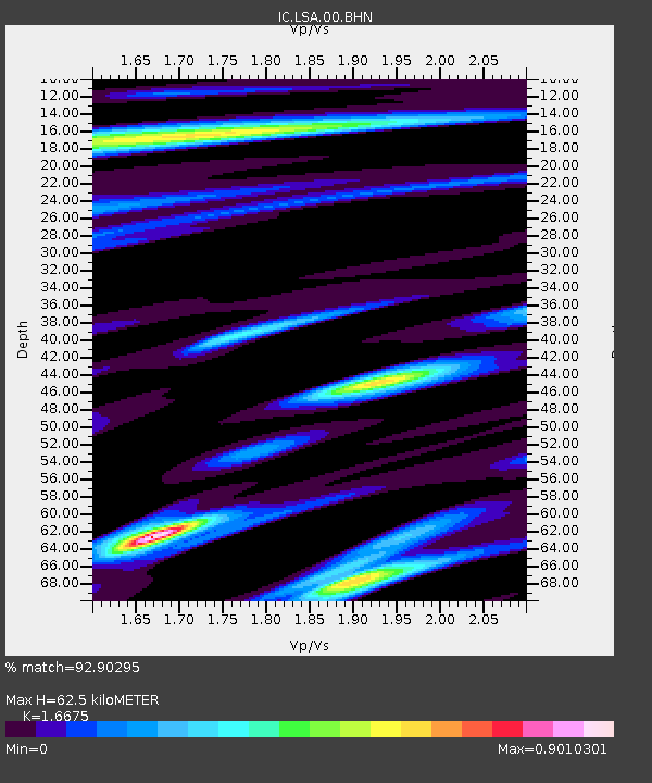
| Estimated Moho Depth: |
62.5 km |
| Estimated Crust Vp/Vs: |
1.67 |
| Assumed Crust Vp: |
6.514 km/s |
| Estimated Crust Vs: |
3.907 km/s |
| Estimated Crust Poisson's Ratio: |
0.22 |
|
| Radial Match: |
92.90295 % |
| Radial Bump: |
400 |
| Transverse Match: |
88.47312 % |
| Transverse Bump: |
400 |
| SOD ConfigId: |
3744 |
| Insert Time: |
2010-03-04 22:38:32.767 +0000 |
| GWidth: |
2.5 |
| Max Bumps: |
400 |
| Tol: |
0.001 |
|
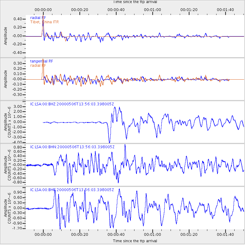
Signal To Noise
| Channel | StoN | STA | LTA |
| IC:LSA:00:BHN:20000506T13:56:03.398005Z | 1.5641496 | 3.8088842E-8 | 2.4351152E-8 |
| IC:LSA:00:BHE:20000506T13:56:03.398005Z | 0.9898501 | 1.9133557E-8 | 1.9329752E-8 |
| IC:LSA:00:BHZ:20000506T13:56:03.398005Z | 1.7257954 | 8.978005E-8 | 5.202242E-8 |
| Arrivals |
| Ps | 6.6 SECOND |
| PpPs | 25 SECOND |
| PsPs/PpSs | 31 SECOND |


