You are here: Home > Network List > CI - Caltech Regional Seismic Network Stations List
> Station VES Vestal, Porterville, CA, USA > Earthquake Result Viewer
VES Vestal, Porterville, CA, USA - Earthquake Result Viewer
| Earthquake location: |
Kuril Islands |
| Earthquake latitude/longitude: |
46.6/153.3 |
| Earthquake time(UTC): |
2006/11/15 (319) 11:14:13 GMT |
| Earthquake Depth: |
10 km |
| Earthquake Magnitude: |
6.5 MB, 7.8 MS, 8.3 MW, 7.9 MW |
| Earthquake Catalog/Contributor: |
WHDF/NEIC |
|
| Network: |
CI Caltech Regional Seismic Network |
| Station: |
VES Vestal, Porterville, CA, USA |
| Lat/Lon: |
35.84 N/119.08 W |
| Elevation: |
154 m |
|
| Distance: |
63.6 deg |
| Az: |
65.039 deg |
| Baz: |
309.693 deg |
| Ray Param: |
0.05949294 |
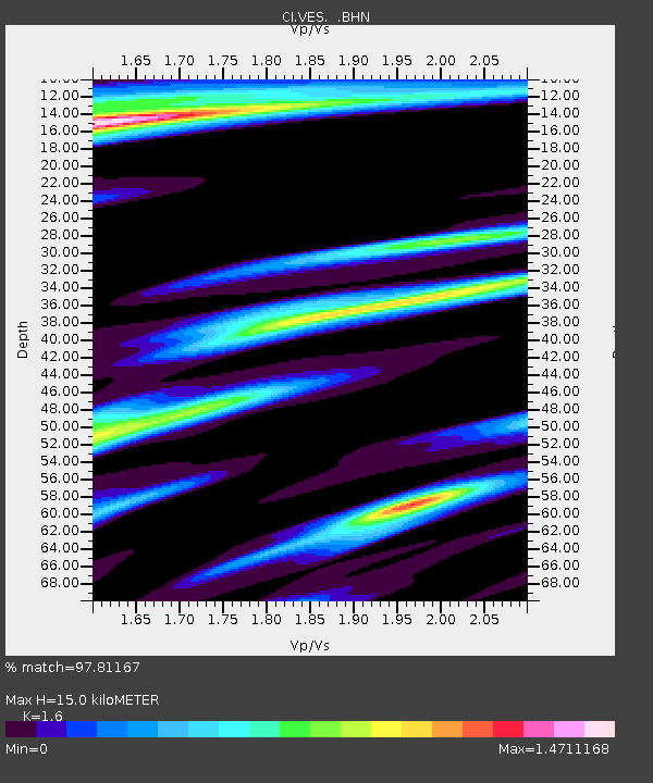
| Estimated Moho Depth: |
15.0 km |
| Estimated Crust Vp/Vs: |
1.60 |
| Assumed Crust Vp: |
6.1 km/s |
| Estimated Crust Vs: |
3.812 km/s |
| Estimated Crust Poisson's Ratio: |
0.18 |
|
| Radial Match: |
97.81167 % |
| Radial Bump: |
400 |
| Transverse Match: |
93.1222 % |
| Transverse Bump: |
400 |
| SOD ConfigId: |
2564 |
| Insert Time: |
2010-02-26 00:00:16.994 +0000 |
| GWidth: |
2.5 |
| Max Bumps: |
400 |
| Tol: |
0.001 |
|

Signal To Noise
| Channel | StoN | STA | LTA |
| CI:VES: :BHN:20061115T11:24:13.096001Z | 2.8536599 | 8.823821E-7 | 3.0921066E-7 |
| CI:VES: :BHE:20061115T11:24:13.096001Z | 1.6107893 | 9.630807E-7 | 5.9789363E-7 |
| CI:VES: :BHZ:20061115T11:24:13.096001Z | 5.720269 | 1.8053868E-6 | 3.156122E-7 |
| Arrivals |
| Ps | 1.5 SECOND |
| PpPs | 6.1 SECOND |
| PsPs/PpSs | 7.7 SECOND |


