You are here: Home > Network List > IC - New China Digital Seismograph Network Stations List
> Station LSA Tibet, China > Earthquake Result Viewer
LSA Tibet, China - Earthquake Result Viewer
| Earthquake location: |
Kuril Islands |
| Earthquake latitude/longitude: |
43.0/146.8 |
| Earthquake time(UTC): |
2000/01/28 (028) 14:21:07 GMT |
| Earthquake Depth: |
61 km |
| Earthquake Magnitude: |
6.7 MB, 6.6 MS, 6.8 MW, 6.8 ME |
| Earthquake Catalog/Contributor: |
WHDF/NEIC |
|
| Network: |
IC New China Digital Seismograph Network |
| Station: |
LSA Tibet, China |
| Lat/Lon: |
29.70 N/91.15 E |
| Elevation: |
3789 m |
|
| Distance: |
46.0 deg |
| Az: |
272.215 deg |
| Baz: |
57.346 deg |
| Ray Param: |
0.07075238 |
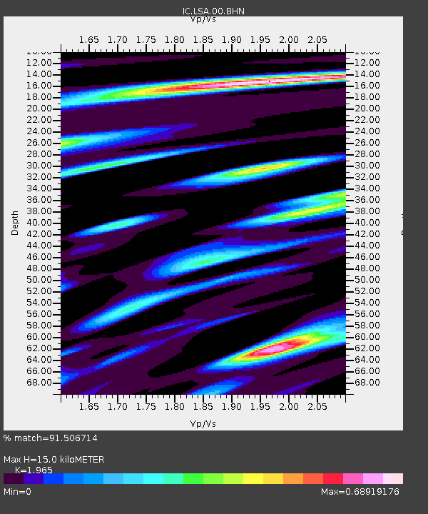
| Estimated Moho Depth: |
15.0 km |
| Estimated Crust Vp/Vs: |
1.97 |
| Assumed Crust Vp: |
6.514 km/s |
| Estimated Crust Vs: |
3.315 km/s |
| Estimated Crust Poisson's Ratio: |
0.33 |
|
| Radial Match: |
91.506714 % |
| Radial Bump: |
400 |
| Transverse Match: |
89.072235 % |
| Transverse Bump: |
400 |
| SOD ConfigId: |
3744 |
| Insert Time: |
2010-03-04 22:38:38.828 +0000 |
| GWidth: |
2.5 |
| Max Bumps: |
400 |
| Tol: |
0.001 |
|
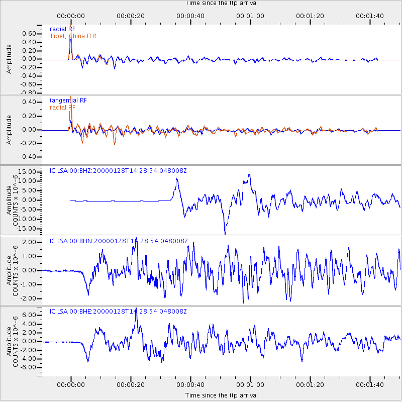
Signal To Noise
| Channel | StoN | STA | LTA |
| IC:LSA:00:BHN:20000128T14:28:54.048008Z | 7.7819905 | 2.1460559E-7 | 2.7577212E-8 |
| IC:LSA:00:BHE:20000128T14:28:54.048008Z | 16.258318 | 6.498805E-7 | 3.9972186E-8 |
| IC:LSA:00:BHZ:20000128T14:28:54.048008Z | 28.41765 | 1.8278844E-6 | 6.432215E-8 |
| Arrivals |
| Ps | 2.4 SECOND |
| PpPs | 6.4 SECOND |
| PsPs/PpSs | 8.8 SECOND |


