You are here: Home > Network List > IC - New China Digital Seismograph Network Stations List
> Station LSA Tibet, China > Earthquake Result Viewer
LSA Tibet, China - Earthquake Result Viewer

| Earthquake location: |
Banda Sea |
| Earthquake latitude/longitude: |
-4.3/123.2 |
| Earthquake time(UTC): |
2000/05/14 (135) 20:08:34 GMT |
| Earthquake Depth: |
33 km |
| Earthquake Magnitude: |
5.9 MB, 5.9 MS, 6.3 MW, 6.2 MW |
| Earthquake Catalog/Contributor: |
WHDF/NEIC |
|
| Network: |
IC New China Digital Seismograph Network |
| Station: |
LSA Tibet, China |
| Lat/Lon: |
29.70 N/91.15 E |
| Elevation: |
3789 m |
|
| Distance: |
45.7 deg |
| Az: |
319.835 deg |
| Baz: |
132.331 deg |
| Ray Param: |
0.07106917 |
| Estimated Moho Depth: |
43.0 km |
| Estimated Crust Vp/Vs: |
1.71 |
| Assumed Crust Vp: |
6.514 km/s |
| Estimated Crust Vs: |
3.815 km/s |
| Estimated Crust Poisson's Ratio: |
0.24 |
|
| Radial Match: |
92.59048 % |
| Radial Bump: |
400 |
| Transverse Match: |
83.5534 % |
| Transverse Bump: |
400 |
| SOD ConfigId: |
3744 |
| Insert Time: |
2010-03-04 22:38:55.345 +0000 |
| GWidth: |
2.5 |
| Max Bumps: |
400 |
| Tol: |
0.001 |
|
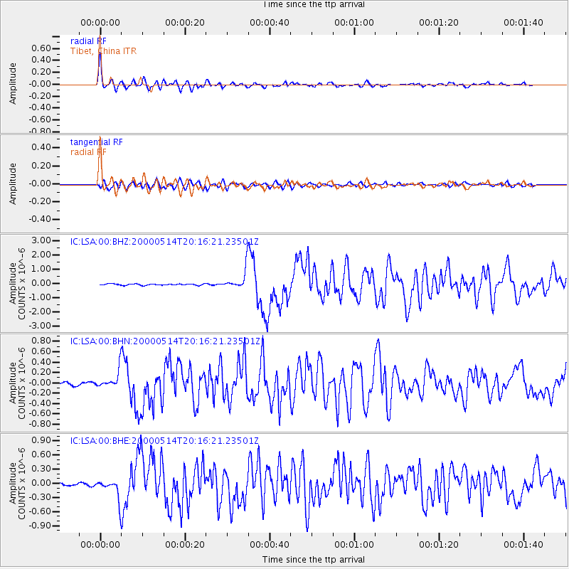
Signal To Noise
| Channel | StoN | STA | LTA |
| IC:LSA:00:BHN:20000514T20:16:21.23501Z | 7.345923 | 1.911622E-7 | 2.6022898E-8 |
| IC:LSA:00:BHE:20000514T20:16:21.23501Z | 8.254591 | 2.3529277E-7 | 2.8504473E-8 |
| IC:LSA:00:BHZ:20000514T20:16:21.23501Z | 15.281129 | 7.4430204E-7 | 4.8707268E-8 |
| Arrivals |
| Ps | 5.0 SECOND |
| PpPs | 17 SECOND |
| PsPs/PpSs | 22 SECOND |


