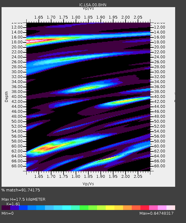
LSA Tibet, China - Earthquake Result Viewer
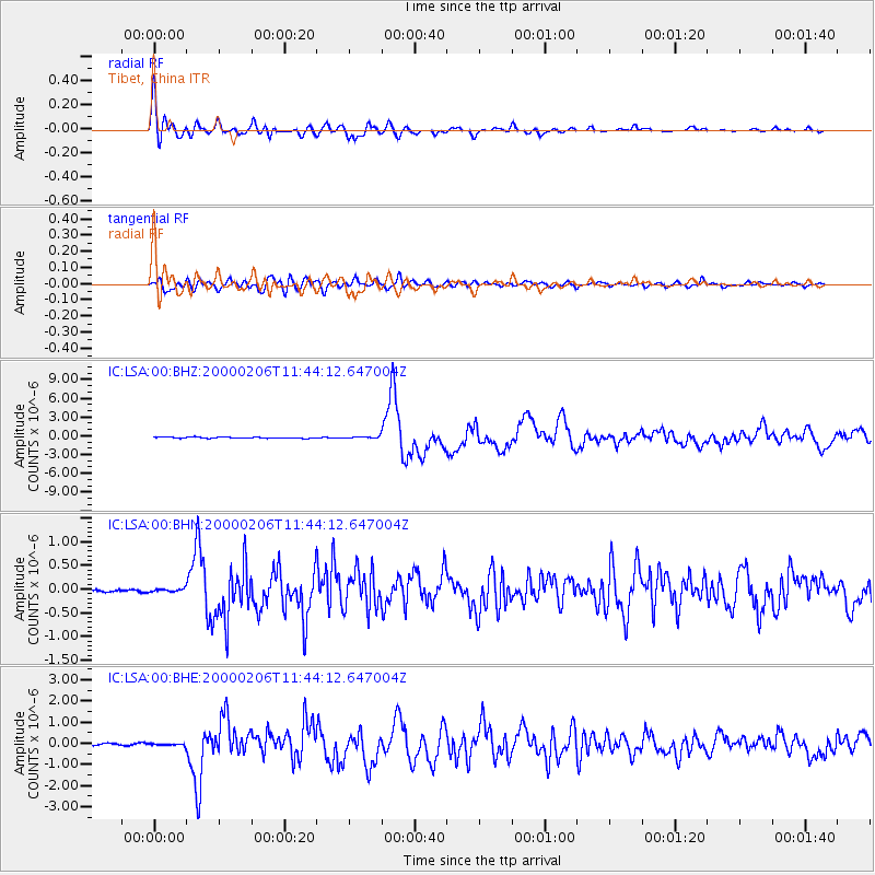
Earthquake location: New Britain Region, P.N.G.
Earthquake latitude/longitude: -5.8/150.9
Earthquake time(UTC): 2000/02/06 (037) 11:33:52 GMT
Earthquake Depth: 33 km
Earthquake Magnitude: 6.6 MB, 6.8 MS, 6.6 MW, 6.3 ME
Earthquake Catalog/Contributor: WHDF/NEIC
Network: IC New China Digital Seismograph Network
Station: LSA Tibet, China
Lat/Lon: 29.70 N/91.15 E
Elevation: 3789 m
Distance: 67.3 deg
Az: 305.44 deg
Baz: 111.315 deg
Ray Param: 0.057019826
Estimated Moho Depth: 17.5 km
Estimated Crust Vp/Vs: 1.61
Assumed Crust Vp: 6.514 km/s
Estimated Crust Vs: 4.046 km/s
Estimated Crust Poisson's Ratio: 0.19
Radial Match: 91.74175 %
Radial Bump: 400
Transverse Match: 85.234825 %
Transverse Bump: 400
SOD ConfigId: 3744
Insert Time: 2010-03-04 22:39:06.896 +0000
GWidth: 2.5
Max Bumps: 400
Tol: 0.001

Signal To Noise

ChannelStoNSTALTA
IC:LSA:00:BHN:20000206T11:44:12.647004Z1.25008273.0752098E-82.460005E-8
IC:LSA:00:BHE:20000206T11:44:12.647004Z1.02503413.611218E-83.5230222E-8
IC:LSA:00:BHZ:20000206T11:44:12.647004Z1.45984691.318898E-79.0344955E-8
Arrivals
Ps1.7 SECOND
PpPs6.7 SECOND
PsPs/PpSs8.4 SECOND