You are here: Home > Network List > IC - New China Digital Seismograph Network Stations List
> Station LSA Tibet, China > Earthquake Result Viewer
LSA Tibet, China - Earthquake Result Viewer
| Earthquake location: |
Santa Cruz Islands |
| Earthquake latitude/longitude: |
-12.0/166.4 |
| Earthquake time(UTC): |
2000/08/03 (216) 01:09:38 GMT |
| Earthquake Depth: |
33 km |
| Earthquake Magnitude: |
5.7 MB, 6.5 MS, 6.7 MW, 6.6 MW |
| Earthquake Catalog/Contributor: |
WHDF/NEIC |
|
| Network: |
IC New China Digital Seismograph Network |
| Station: |
LSA Tibet, China |
| Lat/Lon: |
29.70 N/91.15 E |
| Elevation: |
3789 m |
|
| Distance: |
83.5 deg |
| Az: |
302.104 deg |
| Baz: |
107.737 deg |
| Ray Param: |
0.046127636 |
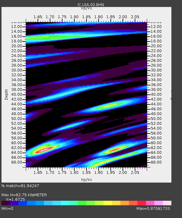
| Estimated Moho Depth: |
62.75 km |
| Estimated Crust Vp/Vs: |
1.67 |
| Assumed Crust Vp: |
6.514 km/s |
| Estimated Crust Vs: |
3.895 km/s |
| Estimated Crust Poisson's Ratio: |
0.22 |
|
| Radial Match: |
91.94247 % |
| Radial Bump: |
400 |
| Transverse Match: |
92.36523 % |
| Transverse Bump: |
400 |
| SOD ConfigId: |
3744 |
| Insert Time: |
2010-03-04 22:39:29.964 +0000 |
| GWidth: |
2.5 |
| Max Bumps: |
400 |
| Tol: |
0.001 |
|

Signal To Noise
| Channel | StoN | STA | LTA |
| IC:LSA:00:BHN:20000803T01:21:32.083027Z | 1.2139736 | 3.5538722E-8 | 2.9274707E-8 |
| IC:LSA:00:BHE:20000803T01:21:32.083027Z | 1.9219828 | 8.142174E-8 | 4.2363407E-8 |
| IC:LSA:00:BHZ:20000803T01:21:32.083027Z | 4.868462 | 2.6927688E-7 | 5.531046E-8 |
| Arrivals |
| Ps | 6.7 SECOND |
| PpPs | 25 SECOND |
| PsPs/PpSs | 32 SECOND |


