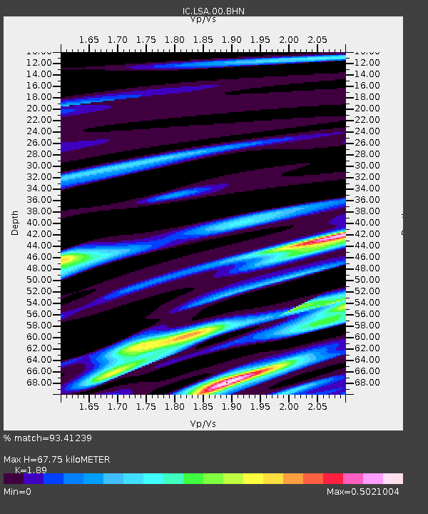
LSA Tibet, China - Earthquake Result Viewer
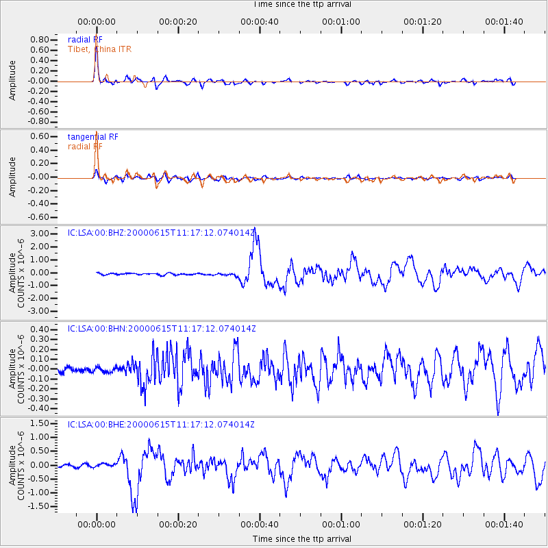
Earthquake location: Southeast Of Shikoku, Japan
Earthquake latitude/longitude: 29.4/132.1
Earthquake time(UTC): 2000/06/15 (167) 11:10:46 GMT
Earthquake Depth: 10 km
Earthquake Magnitude: 6.0 MB, 5.6 MS, 6.1 MW, 6.1 MW
Earthquake Catalog/Contributor: WHDF/NEIC
Network: IC New China Digital Seismograph Network
Station: LSA Tibet, China
Lat/Lon: 29.70 N/91.15 E
Elevation: 3789 m
Distance: 35.5 deg
Az: 280.881 deg
Baz: 80.136 deg
Ray Param: 0.077199146
Estimated Moho Depth: 67.75 km
Estimated Crust Vp/Vs: 1.89
Assumed Crust Vp: 6.514 km/s
Estimated Crust Vs: 3.447 km/s
Estimated Crust Poisson's Ratio: 0.31
Radial Match: 93.41239 %
Radial Bump: 397
Transverse Match: 85.737785 %
Transverse Bump: 400
SOD ConfigId: 3744
Insert Time: 2010-03-04 22:39:38.442 +0000
GWidth: 2.5
Max Bumps: 400
Tol: 0.001

Signal To Noise

ChannelStoNSTALTA
IC:LSA:00:BHN:20000615T11:17:12.074014Z0.901805642.6522125E-82.9410023E-8
IC:LSA:00:BHE:20000615T11:17:12.074014Z2.13307386.45399E-83.0256757E-8
IC:LSA:00:BHZ:20000615T11:17:12.074014Z1.58516139.829777E-86.20112E-8
Arrivals
Ps10.0 SECOND
PpPs28 SECOND
PsPs/PpSs38 SECOND