You are here: Home > Network List > PB - Plate Boundary Observatory Borehole Seismic Network Stations List
> Station B087 fordra087bcs2006, Anza, CA, USA > Earthquake Result Viewer
B087 fordra087bcs2006, Anza, CA, USA - Earthquake Result Viewer
| Earthquake location: |
Guatemala |
| Earthquake latitude/longitude: |
14.2/-90.9 |
| Earthquake time(UTC): |
2015/12/07 (341) 22:53:36 GMT |
| Earthquake Depth: |
109 km |
| Earthquake Magnitude: |
5.7 MB |
| Earthquake Catalog/Contributor: |
NEIC PDE/NEIC COMCAT |
|
| Network: |
PB Plate Boundary Observatory Borehole Seismic Network |
| Station: |
B087 fordra087bcs2006, Anza, CA, USA |
| Lat/Lon: |
33.50 N/116.60 W |
| Elevation: |
1139 m |
|
| Distance: |
30.2 deg |
| Az: |
313.874 deg |
| Baz: |
123.218 deg |
| Ray Param: |
0.07920239 |
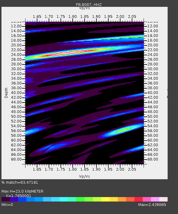
| Estimated Moho Depth: |
23.0 km |
| Estimated Crust Vp/Vs: |
1.79 |
| Assumed Crust Vp: |
6.264 km/s |
| Estimated Crust Vs: |
3.509 km/s |
| Estimated Crust Poisson's Ratio: |
0.27 |
|
| Radial Match: |
83.47161 % |
| Radial Bump: |
400 |
| Transverse Match: |
68.67222 % |
| Transverse Bump: |
400 |
| SOD ConfigId: |
7422571 |
| Insert Time: |
2019-04-21 13:55:32.917 +0000 |
| GWidth: |
2.5 |
| Max Bumps: |
400 |
| Tol: |
0.001 |
|

Signal To Noise
| Channel | StoN | STA | LTA |
| PB:B087: :HHZ:20151207T22:59:07.459004Z | 11.181154 | 5.072015E-8 | 4.5362176E-9 |
| PB:B087: :HH1:20151207T22:59:07.459004Z | 3.7751093 | 1.8643297E-8 | 4.9384785E-9 |
| PB:B087: :HH2:20151207T22:59:07.459004Z | 4.1993747 | 2.0557849E-8 | 4.8954543E-9 |
| Arrivals |
| Ps | 3.1 SECOND |
| PpPs | 9.5 SECOND |
| PsPs/PpSs | 13 SECOND |


