You are here: Home > Network List > IC - New China Digital Seismograph Network Stations List
> Station LSA Tibet, China > Earthquake Result Viewer
LSA Tibet, China - Earthquake Result Viewer
| Earthquake location: |
Banda Sea |
| Earthquake latitude/longitude: |
-7.3/128.6 |
| Earthquake time(UTC): |
2009/01/22 (022) 20:16:34 GMT |
| Earthquake Depth: |
147 km |
| Earthquake Magnitude: |
6.1 MB, 6.1 MW, 6.1 MW |
| Earthquake Catalog/Contributor: |
WHDF/NEIC |
|
| Network: |
IC New China Digital Seismograph Network |
| Station: |
LSA Tibet, China |
| Lat/Lon: |
29.70 N/91.15 E |
| Elevation: |
3789 m |
|
| Distance: |
51.4 deg |
| Az: |
317.469 deg |
| Baz: |
129.581 deg |
| Ray Param: |
0.066899486 |
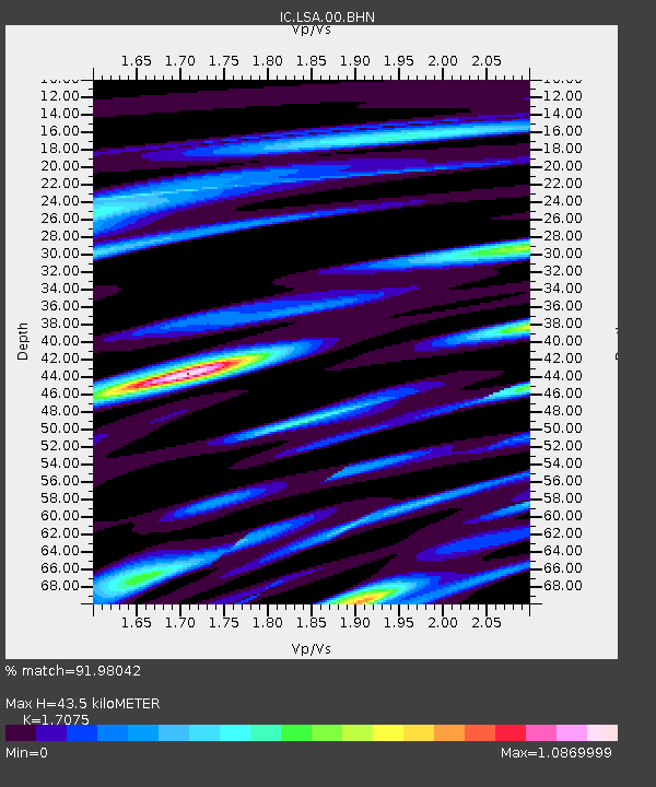
| Estimated Moho Depth: |
43.5 km |
| Estimated Crust Vp/Vs: |
1.71 |
| Assumed Crust Vp: |
6.514 km/s |
| Estimated Crust Vs: |
3.815 km/s |
| Estimated Crust Poisson's Ratio: |
0.24 |
|
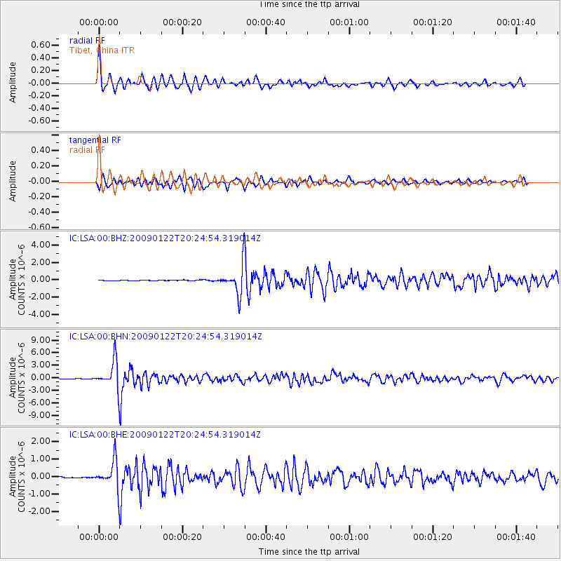
| Radial Match: |
91.98042 % |
| Radial Bump: |
370 |
| Transverse Match: |
87.19005 % |
| Transverse Bump: |
400 |
| SOD ConfigId: |
2658 |
| Insert Time: |
2010-03-04 22:39:42.836 +0000 |
| GWidth: |
2.5 |
| Max Bumps: |
400 |
| Tol: |
0.001 |
|
Signal To Noise
| Channel | StoN | STA | LTA |
| IC:LSA:00:BHN:20090122T20:24:54.319014Z | 45.511356 | 3.429819E-6 | 7.5361825E-8 |
| IC:LSA:00:BHE:20090122T20:24:54.319014Z | 32.438065 | 8.202475E-7 | 2.5286573E-8 |
| IC:LSA:00:BHZ:20090122T20:24:54.319014Z | 40.97065 | 1.6003745E-6 | 3.9061486E-8 |
| Arrivals |
| Ps | 5.0 SECOND |
| PpPs | 17 SECOND |
| PsPs/PpSs | 22 SECOND |


