You are here: Home > Network List > TA - USArray Transportable Network (new EarthScope stations) Stations List
> Station 109C Camp Elliot, Mirimar, CA, USA > Earthquake Result Viewer
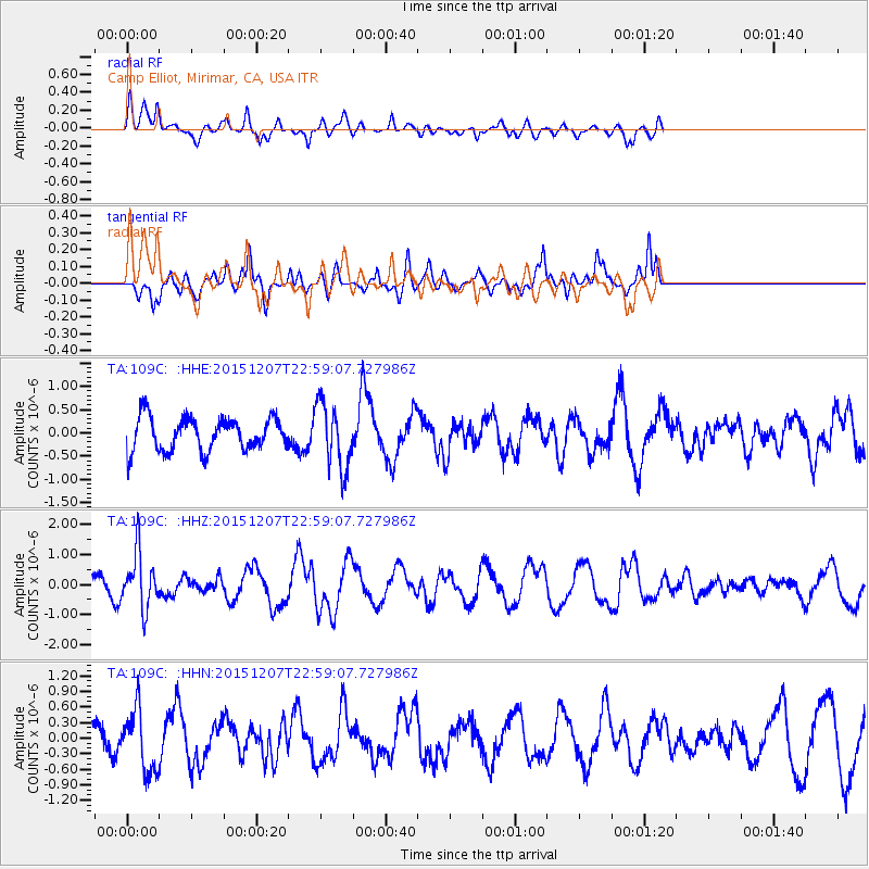
109C Camp Elliot, Mirimar, CA, USA - Earthquake Result Viewer
*The percent match for this event was below the threshold and hence no stack was calculated.
| Earthquake location: |
Guatemala |
| Earthquake latitude/longitude: |
14.2/-90.9 |
| Earthquake time(UTC): |
2015/12/07 (341) 22:53:36 GMT |
| Earthquake Depth: |
109 km |
| Earthquake Magnitude: |
5.7 MB |
| Earthquake Catalog/Contributor: |
NEIC PDE/NEIC COMCAT |
|
| Network: |
TA USArray Transportable Network (new EarthScope stations) |
| Station: |
109C Camp Elliot, Mirimar, CA, USA |
| Lat/Lon: |
32.89 N/117.11 W |
| Elevation: |
150 m |
|
| Distance: |
30.3 deg |
| Az: |
312.412 deg |
| Baz: |
121.682 deg |
| Ray Param: |
$rayparam |
*The percent match for this event was below the threshold and hence was not used in the summary stack. |
|
| Radial Match: |
53.97574 % |
| Radial Bump: |
400 |
| Transverse Match: |
65.58203 % |
| Transverse Bump: |
381 |
| SOD ConfigId: |
7422571 |
| Insert Time: |
2019-04-21 13:56:02.227 +0000 |
| GWidth: |
2.5 |
| Max Bumps: |
400 |
| Tol: |
0.001 |
|
Signal To Noise
| Channel | StoN | STA | LTA |
| TA:109C: :HHZ:20151207T22:59:07.727986Z | 2.0949504 | 9.2240776E-7 | 4.4030054E-7 |
| TA:109C: :HHN:20151207T22:59:07.727986Z | 1.6251687 | 5.912499E-7 | 3.638083E-7 |
| TA:109C: :HHE:20151207T22:59:07.727986Z | 2.002247 | 7.116464E-7 | 3.5542385E-7 |
| Arrivals |
| Ps | |
| PpPs | |
| PsPs/PpSs | |


