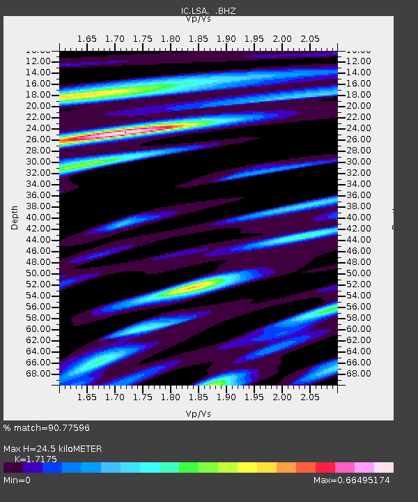
LSA Tibet, China - Earthquake Result Viewer
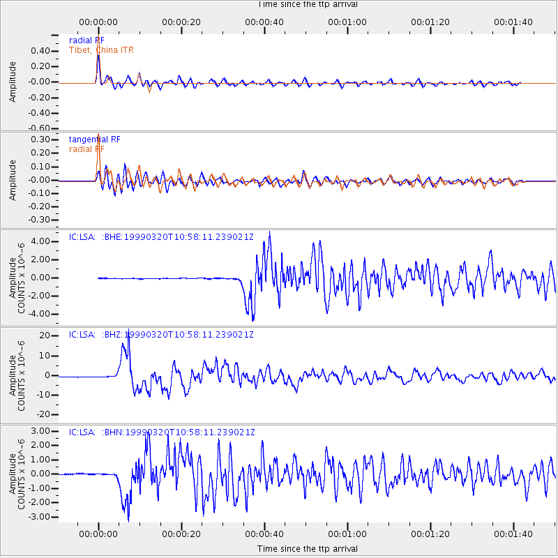
Earthquake location: Andreanof Islands, Aleutian Is.
Earthquake latitude/longitude: 51.6/-177.7
Earthquake time(UTC): 1999/03/20 (079) 10:47:45 GMT
Earthquake Depth: 33 km
Earthquake Magnitude: 6.3 MB, 6.8 MS, 6.9 MW, 6.8 ME
Earthquake Catalog/Contributor: WHDF/NEIC
Network: IC New China Digital Seismograph Network
Station: LSA Tibet, China
Lat/Lon: 29.70 N/91.15 E
Elevation: 3789 m
Distance: 68.0 deg
Az: 290.288 deg
Baz: 42.266 deg
Ray Param: 0.056516886
Estimated Moho Depth: 24.5 km
Estimated Crust Vp/Vs: 1.72
Assumed Crust Vp: 6.514 km/s
Estimated Crust Vs: 3.793 km/s
Estimated Crust Poisson's Ratio: 0.24
Radial Match: 90.77596 %
Radial Bump: 400
Transverse Match: 81.72667 %
Transverse Bump: 400
SOD ConfigId: 4480
Insert Time: 2010-03-04 22:39:53.698 +0000
GWidth: 2.5
Max Bumps: 400
Tol: 0.001

Signal To Noise

ChannelStoNSTALTA
IC:LSA: :BHZ:19990320T10:58:11.239021Z9.8116819.2853185E-79.4635354E-8
IC:LSA: :BHN:19990320T10:58:11.239021Z4.60825971.2422909E-72.6957919E-8
IC:LSA: :BHE:19990320T10:58:11.239021Z8.0669172.2036166E-72.731671E-8
Arrivals
Ps2.8 SECOND
PpPs9.8 SECOND
PsPs/PpSs13 SECOND