You are here: Home > Network List > CI - Caltech Regional Seismic Network Stations List
> Station VES Vestal, Porterville, CA, USA > Earthquake Result Viewer
VES Vestal, Porterville, CA, USA - Earthquake Result Viewer
| Earthquake location: |
Eastern Siberia, Russia |
| Earthquake latitude/longitude: |
60.9/167.1 |
| Earthquake time(UTC): |
2006/04/20 (110) 23:25:02 GMT |
| Earthquake Depth: |
22 km |
| Earthquake Magnitude: |
6.8 MB, 7.6 MS, 7.6 MW, 7.3 MW |
| Earthquake Catalog/Contributor: |
WHDF/NEIC |
|
| Network: |
CI Caltech Regional Seismic Network |
| Station: |
VES Vestal, Porterville, CA, USA |
| Lat/Lon: |
35.84 N/119.08 W |
| Elevation: |
154 m |
|
| Distance: |
51.7 deg |
| Az: |
83.639 deg |
| Baz: |
323.344 deg |
| Ray Param: |
0.06718607 |
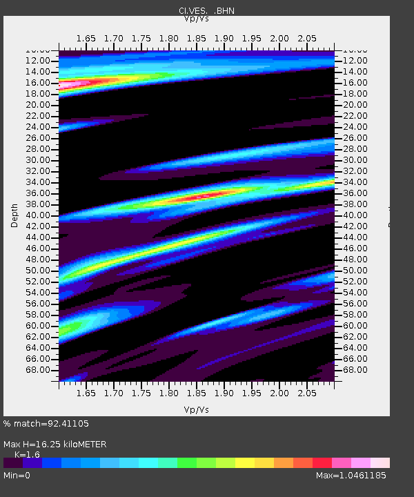
| Estimated Moho Depth: |
16.25 km |
| Estimated Crust Vp/Vs: |
1.60 |
| Assumed Crust Vp: |
6.1 km/s |
| Estimated Crust Vs: |
3.812 km/s |
| Estimated Crust Poisson's Ratio: |
0.18 |
|
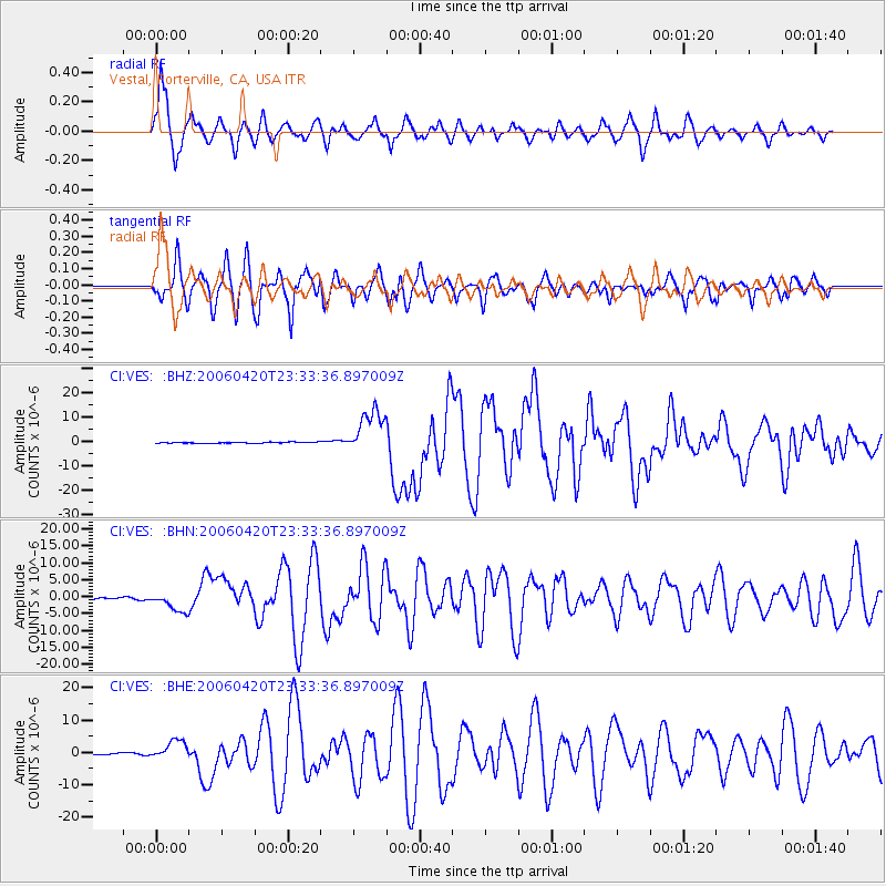
| Radial Match: |
92.41105 % |
| Radial Bump: |
396 |
| Transverse Match: |
90.94502 % |
| Transverse Bump: |
400 |
| SOD ConfigId: |
2669 |
| Insert Time: |
2010-02-26 00:00:26.920 +0000 |
| GWidth: |
2.5 |
| Max Bumps: |
400 |
| Tol: |
0.001 |
|
Signal To Noise
| Channel | StoN | STA | LTA |
| CI:VES: :BHN:20060420T23:33:36.897009Z | 6.8896856 | 2.9839196E-6 | 4.3309953E-7 |
| CI:VES: :BHE:20060420T23:33:36.897009Z | 5.2300987 | 2.953556E-6 | 5.647228E-7 |
| CI:VES: :BHZ:20060420T23:33:36.897009Z | 45.497753 | 9.210222E-6 | 2.0243246E-7 |
| Arrivals |
| Ps | 1.7 SECOND |
| PpPs | 6.6 SECOND |
| PsPs/PpSs | 8.2 SECOND |


