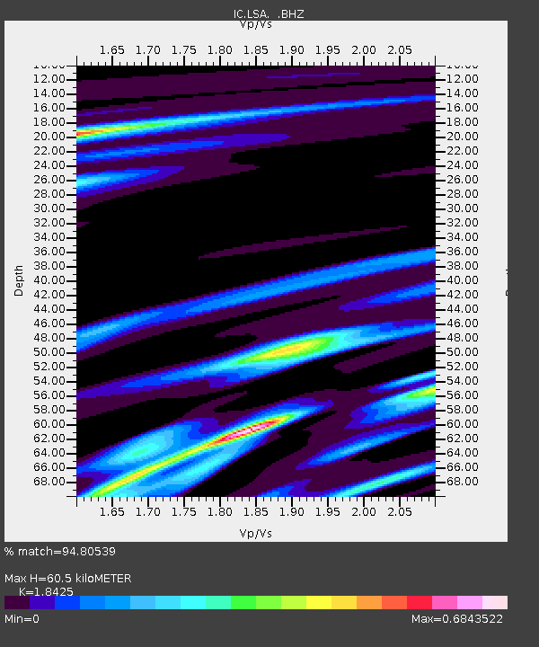
LSA Tibet, China - Earthquake Result Viewer
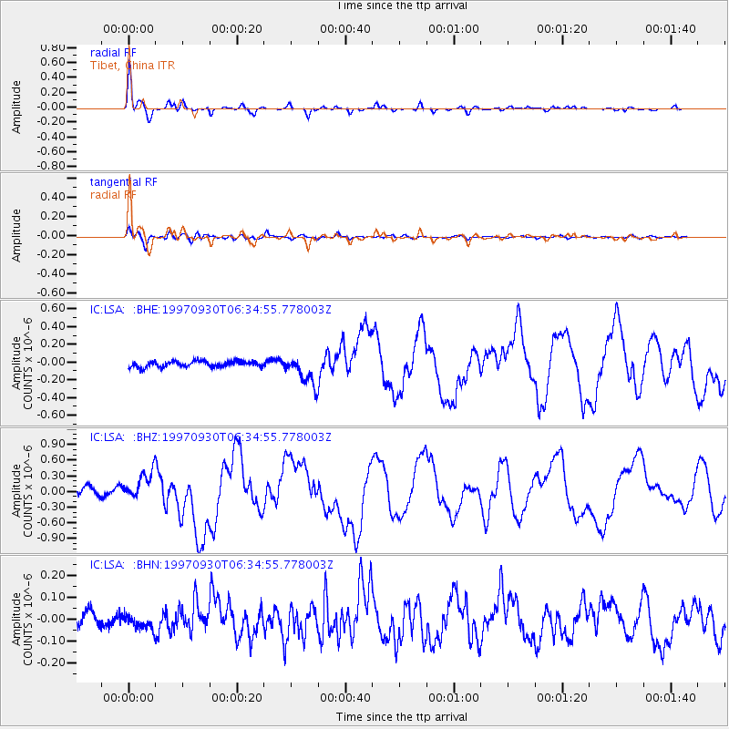
Earthquake location: Southeast Of Honshu, Japan
Earthquake latitude/longitude: 32.0/141.9
Earthquake time(UTC): 1997/09/30 (273) 06:27:24 GMT
Earthquake Depth: 10 km
Earthquake Magnitude: 5.5 MB, 6.5 MS, 6.1 UNKNOWN, 6.0 MW
Earthquake Catalog/Contributor: WHDF/NEIC
Network: IC New China Digital Seismograph Network
Station: LSA Tibet, China
Lat/Lon: 29.70 N/91.15 E
Elevation: 3789 m
Distance: 43.3 deg
Az: 280.834 deg
Baz: 73.648 deg
Ray Param: 0.07264318
Estimated Moho Depth: 60.5 km
Estimated Crust Vp/Vs: 1.84
Assumed Crust Vp: 6.514 km/s
Estimated Crust Vs: 3.536 km/s
Estimated Crust Poisson's Ratio: 0.29
Radial Match: 94.80539 %
Radial Bump: 331
Transverse Match: 87.594284 %
Transverse Bump: 400
SOD ConfigId: 4480
Insert Time: 2010-03-04 22:40:10.535 +0000
GWidth: 2.5
Max Bumps: 400
Tol: 0.001

Signal To Noise

ChannelStoNSTALTA
IC:LSA: :BHZ:19970930T06:34:55.778003Z4.18093442.7935047E-76.681532E-8
IC:LSA: :BHN:19970930T06:34:55.778003Z1.36493733.2230282E-82.3613014E-8
IC:LSA: :BHE:19970930T06:34:55.778003Z4.7759811.6006922E-73.3515462E-8
Arrivals
Ps8.4 SECOND
PpPs25 SECOND
PsPs/PpSs33 SECOND