You are here: Home > Network List > IC - New China Digital Seismograph Network Stations List
> Station LSA Tibet, China > Earthquake Result Viewer
LSA Tibet, China - Earthquake Result Viewer
| Earthquake location: |
Mindanao, Philippines |
| Earthquake latitude/longitude: |
9.8/125.8 |
| Earthquake time(UTC): |
1997/10/06 (279) 12:30:05 GMT |
| Earthquake Depth: |
106 km |
| Earthquake Magnitude: |
5.9 MB, 6.5 UNKNOWN, 6.4 MW |
| Earthquake Catalog/Contributor: |
WHDF/NEIC |
|
| Network: |
IC New China Digital Seismograph Network |
| Station: |
LSA Tibet, China |
| Lat/Lon: |
29.70 N/91.15 E |
| Elevation: |
3789 m |
|
| Distance: |
37.9 deg |
| Az: |
306.43 deg |
| Baz: |
114.293 deg |
| Ray Param: |
0.07550329 |
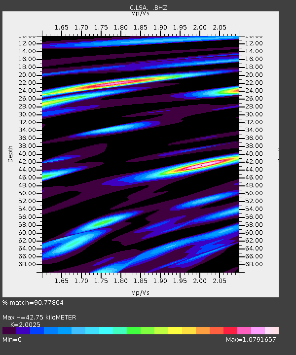
| Estimated Moho Depth: |
42.75 km |
| Estimated Crust Vp/Vs: |
2.00 |
| Assumed Crust Vp: |
6.514 km/s |
| Estimated Crust Vs: |
3.253 km/s |
| Estimated Crust Poisson's Ratio: |
0.33 |
|
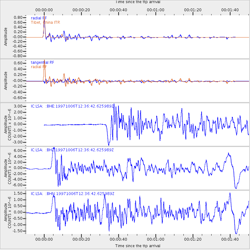
| Radial Match: |
90.77804 % |
| Radial Bump: |
400 |
| Transverse Match: |
65.02275 % |
| Transverse Bump: |
400 |
| SOD ConfigId: |
4480 |
| Insert Time: |
2010-03-04 22:40:14.487 +0000 |
| GWidth: |
2.5 |
| Max Bumps: |
400 |
| Tol: |
0.001 |
|
Signal To Noise
| Channel | StoN | STA | LTA |
| IC:LSA: :BHZ:19971006T12:36:42.625989Z | 20.437943 | 2.065559E-6 | 1.0106493E-7 |
| IC:LSA: :BHN:19971006T12:36:42.625989Z | 21.58053 | 3.9281178E-7 | 1.8202138E-8 |
| IC:LSA: :BHE:19971006T12:36:42.625989Z | 24.18091 | 9.568626E-7 | 3.957099E-8 |
| Arrivals |
| Ps | 7.0 SECOND |
| PpPs | 18 SECOND |
| PsPs/PpSs | 25 SECOND |


