You are here: Home > Network List > CI - Caltech Regional Seismic Network Stations List
> Station MPM Manuel Prospect Mine, California, USA > Earthquake Result Viewer
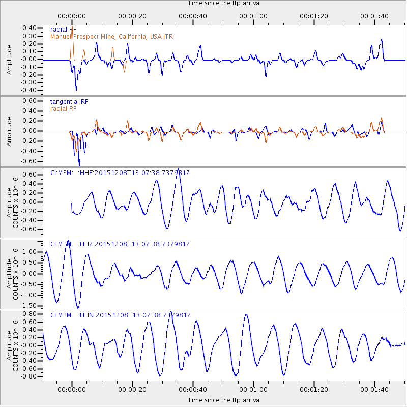
MPM Manuel Prospect Mine, California, USA - Earthquake Result Viewer
*The percent match for this event was below the threshold and hence no stack was calculated.
| Earthquake location: |
Near Coast Of Central Chile |
| Earthquake latitude/longitude: |
-30.8/-71.7 |
| Earthquake time(UTC): |
2015/12/08 (342) 12:56:07 GMT |
| Earthquake Depth: |
30 km |
| Earthquake Magnitude: |
5.6 MB |
| Earthquake Catalog/Contributor: |
NEIC PDE/NEIC COMCAT |
|
| Network: |
CI Caltech Regional Seismic Network |
| Station: |
MPM Manuel Prospect Mine, California, USA |
| Lat/Lon: |
36.06 N/117.49 W |
| Elevation: |
185 m |
|
| Distance: |
79.2 deg |
| Az: |
323.775 deg |
| Baz: |
141.125 deg |
| Ray Param: |
$rayparam |
*The percent match for this event was below the threshold and hence was not used in the summary stack. |
|
| Radial Match: |
74.96422 % |
| Radial Bump: |
400 |
| Transverse Match: |
70.35917 % |
| Transverse Bump: |
400 |
| SOD ConfigId: |
7422571 |
| Insert Time: |
2019-04-21 13:59:14.793 +0000 |
| GWidth: |
2.5 |
| Max Bumps: |
400 |
| Tol: |
0.001 |
|
Signal To Noise
| Channel | StoN | STA | LTA |
| CI:MPM: :HHZ:20151208T13:07:38.737981Z | 2.3932295 | 9.81595E-7 | 4.10155E-7 |
| CI:MPM: :HHN:20151208T13:07:38.737981Z | 1.6614588 | 3.8860253E-7 | 2.3389237E-7 |
| CI:MPM: :HHE:20151208T13:07:38.737981Z | 2.1316648 | 3.62181E-7 | 1.6990523E-7 |
| Arrivals |
| Ps | |
| PpPs | |
| PsPs/PpSs | |


