You are here: Home > Network List > IC - New China Digital Seismograph Network Stations List
> Station LSA Tibet, China > Earthquake Result Viewer
LSA Tibet, China - Earthquake Result Viewer
| Earthquake location: |
Aegean Sea |
| Earthquake latitude/longitude: |
39.1/24.2 |
| Earthquake time(UTC): |
2001/07/26 (207) 00:21:36 GMT |
| Earthquake Depth: |
10 km |
| Earthquake Magnitude: |
6.0 MB, 6.6 MS, 7.0 ME, 6.1 ML |
| Earthquake Catalog/Contributor: |
WHDF/NEIC |
|
| Network: |
IC New China Digital Seismograph Network |
| Station: |
LSA Tibet, China |
| Lat/Lon: |
29.70 N/91.15 E |
| Elevation: |
3789 m |
|
| Distance: |
54.9 deg |
| Az: |
78.034 deg |
| Baz: |
298.908 deg |
| Ray Param: |
0.065153494 |
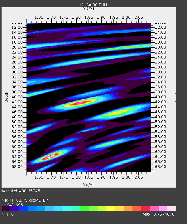
| Estimated Moho Depth: |
63.75 km |
| Estimated Crust Vp/Vs: |
1.70 |
| Assumed Crust Vp: |
6.514 km/s |
| Estimated Crust Vs: |
3.843 km/s |
| Estimated Crust Poisson's Ratio: |
0.23 |
|
| Radial Match: |
90.65845 % |
| Radial Bump: |
400 |
| Transverse Match: |
89.25087 % |
| Transverse Bump: |
400 |
| SOD ConfigId: |
4714 |
| Insert Time: |
2010-03-04 22:40:36.581 +0000 |
| GWidth: |
2.5 |
| Max Bumps: |
400 |
| Tol: |
0.001 |
|
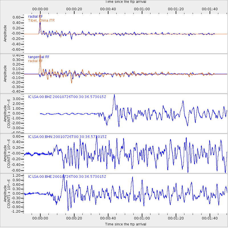
Signal To Noise
| Channel | StoN | STA | LTA |
| IC:LSA:00:BHN:20010726T00:30:36.573015Z | 0.9464286 | 2.426097E-8 | 2.563423E-8 |
| IC:LSA:00:BHE:20010726T00:30:36.573015Z | 1.3364532 | 3.7911615E-8 | 2.8367335E-8 |
| IC:LSA:00:BHZ:20010726T00:30:36.573015Z | 1.677933 | 1.3837858E-7 | 8.2469676E-8 |
| Arrivals |
| Ps | 7.2 SECOND |
| PpPs | 25 SECOND |
| PsPs/PpSs | 32 SECOND |


