You are here: Home > Network List > IC - New China Digital Seismograph Network Stations List
> Station LSA Tibet, China > Earthquake Result Viewer
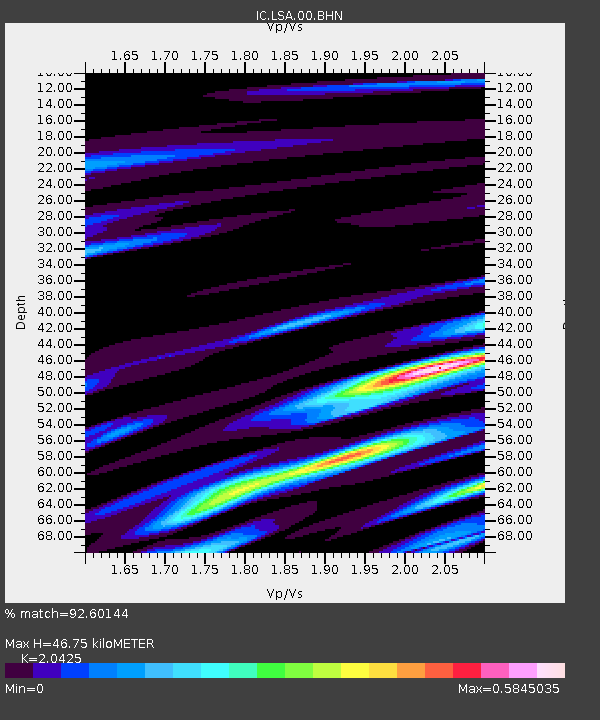
LSA Tibet, China - Earthquake Result Viewer
| Earthquake location: |
Western Honshu, Japan |
| Earthquake latitude/longitude: |
34.1/132.5 |
| Earthquake time(UTC): |
2001/03/24 (083) 06:27:53 GMT |
| Earthquake Depth: |
50 km |
| Earthquake Magnitude: |
6.4 MB, 6.5 MS, 6.8 MW, 6.4 ME |
| Earthquake Catalog/Contributor: |
WHDF/NEIC |
|
| Network: |
IC New China Digital Seismograph Network |
| Station: |
LSA Tibet, China |
| Lat/Lon: |
29.70 N/91.15 E |
| Elevation: |
3789 m |
|
| Distance: |
35.2 deg |
| Az: |
274.469 deg |
| Baz: |
71.994 deg |
| Ray Param: |
0.07721005 |
| Estimated Moho Depth: |
46.75 km |
| Estimated Crust Vp/Vs: |
2.04 |
| Assumed Crust Vp: |
6.514 km/s |
| Estimated Crust Vs: |
3.189 km/s |
| Estimated Crust Poisson's Ratio: |
0.34 |
|
| Radial Match: |
92.60144 % |
| Radial Bump: |
400 |
| Transverse Match: |
88.01042 % |
| Transverse Bump: |
400 |
| SOD ConfigId: |
4714 |
| Insert Time: |
2010-03-04 22:40:37.658 +0000 |
| GWidth: |
2.5 |
| Max Bumps: |
400 |
| Tol: |
0.001 |
|

Signal To Noise
| Channel | StoN | STA | LTA |
| IC:LSA:00:BHN:20010324T06:34:12.845991Z | 2.428783 | 6.5944306E-8 | 2.7151172E-8 |
| IC:LSA:00:BHE:20010324T06:34:12.845991Z | 15.828904 | 5.5282646E-7 | 3.4925126E-8 |
| IC:LSA:00:BHZ:20010324T06:34:12.845991Z | 14.085739 | 1.1944455E-6 | 8.479821E-8 |
| Arrivals |
| Ps | 8.0 SECOND |
| PpPs | 20 SECOND |
| PsPs/PpSs | 28 SECOND |


