You are here: Home > Network List > IU - Global Seismograph Network (GSN - IRIS/USGS) Stations List
> Station JOHN Johnston Island, USA > Earthquake Result Viewer
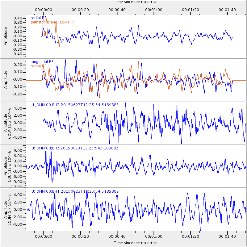
JOHN Johnston Island, USA - Earthquake Result Viewer
*The percent match for this event was below the threshold and hence no stack was calculated.
| Earthquake location: |
Bonin Islands, Japan Region |
| Earthquake latitude/longitude: |
27.7/139.8 |
| Earthquake time(UTC): |
2015/06/23 (174) 12:18:29 GMT |
| Earthquake Depth: |
456 km |
| Earthquake Magnitude: |
6.3 MO |
| Earthquake Catalog/Contributor: |
NEIC PDE/NEIC ALERT |
|
| Network: |
IU Global Seismograph Network (GSN - IRIS/USGS) |
| Station: |
JOHN Johnston Island, USA |
| Lat/Lon: |
16.73 N/169.53 W |
| Elevation: |
2.0 m |
|
| Distance: |
47.9 deg |
| Az: |
92.061 deg |
| Baz: |
292.327 deg |
| Ray Param: |
$rayparam |
*The percent match for this event was below the threshold and hence was not used in the summary stack. |
|
| Radial Match: |
48.542175 % |
| Radial Bump: |
400 |
| Transverse Match: |
62.114285 % |
| Transverse Bump: |
400 |
| SOD ConfigId: |
976571 |
| Insert Time: |
2015-07-07 12:34:47.454 +0000 |
| GWidth: |
2.5 |
| Max Bumps: |
400 |
| Tol: |
0.001 |
|
Signal To Noise
| Channel | StoN | STA | LTA |
| IU:JOHN:00:BHZ:20150623T12:25:54.518988Z | 3.2117684 | 4.585653E-6 | 1.4277659E-6 |
| IU:JOHN:00:BH1:20150623T12:25:54.518988Z | 0.8761874 | 1.2353206E-6 | 1.4098817E-6 |
| IU:JOHN:00:BH2:20150623T12:25:54.518988Z | 1.1476828 | 1.7738655E-6 | 1.5456061E-6 |
| Arrivals |
| Ps | |
| PpPs | |
| PsPs/PpSs | |


