You are here: Home > Network List > IC - New China Digital Seismograph Network Stations List
> Station LSA Tibet, China > Earthquake Result Viewer
LSA Tibet, China - Earthquake Result Viewer
| Earthquake location: |
Mid-Indian Ridge |
| Earthquake latitude/longitude: |
-40.3/78.4 |
| Earthquake time(UTC): |
2001/01/15 (015) 05:52:16 GMT |
| Earthquake Depth: |
10 km |
| Earthquake Magnitude: |
5.7 MB, 6.3 MS, 6.4 MW, 6.3 MW |
| Earthquake Catalog/Contributor: |
WHDF/NEIC |
|
| Network: |
IC New China Digital Seismograph Network |
| Station: |
LSA Tibet, China |
| Lat/Lon: |
29.70 N/91.15 E |
| Elevation: |
3789 m |
|
| Distance: |
70.7 deg |
| Az: |
11.774 deg |
| Baz: |
190.326 deg |
| Ray Param: |
0.054813642 |
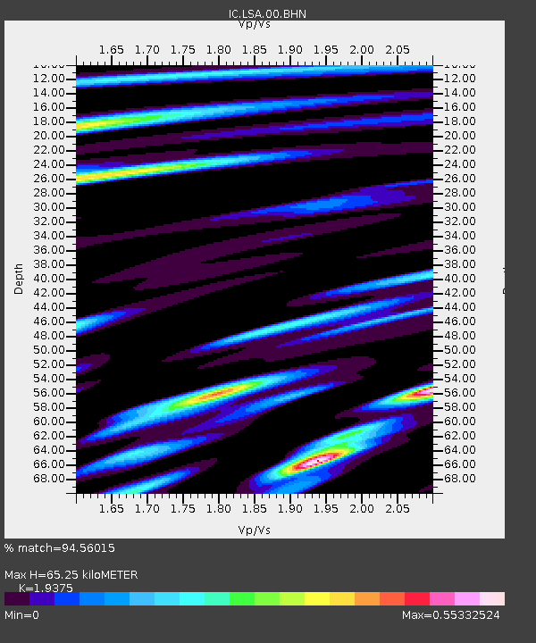
| Estimated Moho Depth: |
65.25 km |
| Estimated Crust Vp/Vs: |
1.94 |
| Assumed Crust Vp: |
6.514 km/s |
| Estimated Crust Vs: |
3.362 km/s |
| Estimated Crust Poisson's Ratio: |
0.32 |
|
| Radial Match: |
94.56015 % |
| Radial Bump: |
400 |
| Transverse Match: |
84.682106 % |
| Transverse Bump: |
400 |
| SOD ConfigId: |
3744 |
| Insert Time: |
2010-03-04 22:40:43.031 +0000 |
| GWidth: |
2.5 |
| Max Bumps: |
400 |
| Tol: |
0.001 |
|
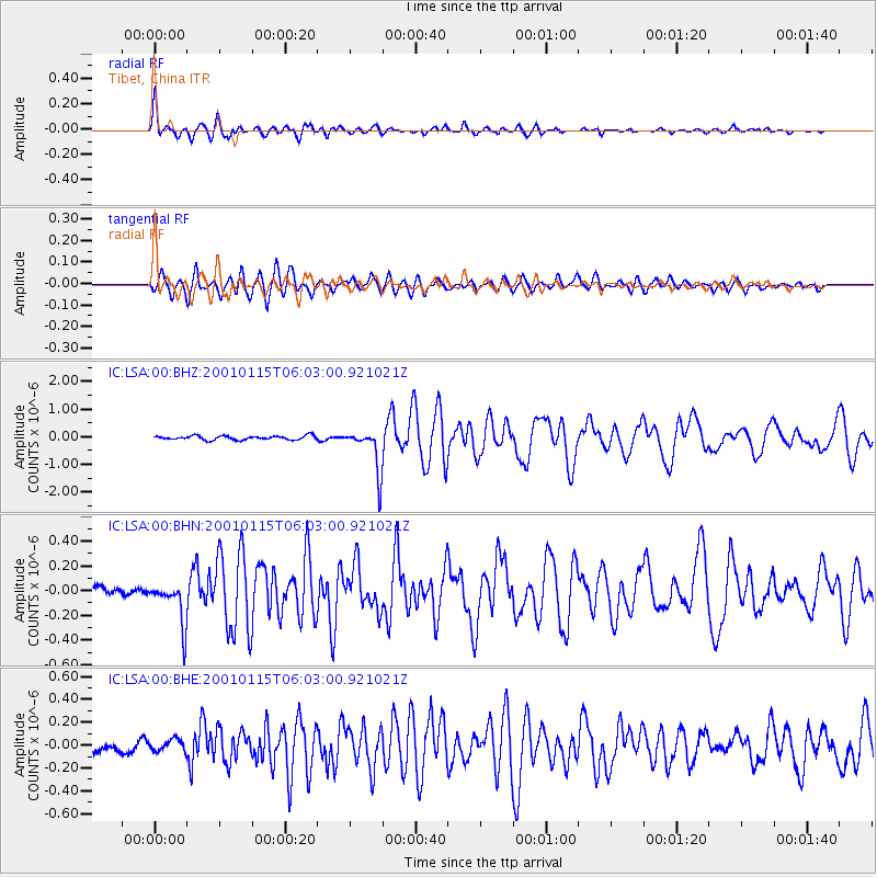
Signal To Noise
| Channel | StoN | STA | LTA |
| IC:LSA:00:BHN:20010115T06:03:00.921021Z | 6.638017 | 1.7257095E-7 | 2.5997364E-8 |
| IC:LSA:00:BHE:20010115T06:03:00.921021Z | 1.5954283 | 5.691395E-8 | 3.567315E-8 |
| IC:LSA:00:BHZ:20010115T06:03:00.921021Z | 10.839584 | 7.873738E-7 | 7.263875E-8 |
| Arrivals |
| Ps | 9.7 SECOND |
| PpPs | 28 SECOND |
| PsPs/PpSs | 38 SECOND |


