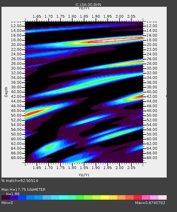
LSA Tibet, China - Earthquake Result Viewer
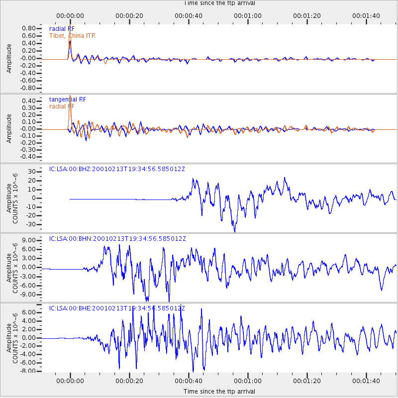
Earthquake location: Southern Sumatra, Indonesia
Earthquake latitude/longitude: -4.7/102.6
Earthquake time(UTC): 2001/02/13 (044) 19:28:30 GMT
Earthquake Depth: 36 km
Earthquake Magnitude: 6.2 MB, 7.2 MS, 7.4 MW, 7.0 ME
Earthquake Catalog/Contributor: WHDF/NEIC
Network: IC New China Digital Seismograph Network
Station: LSA Tibet, China
Lat/Lon: 29.70 N/91.15 E
Elevation: 3789 m
Distance: 35.9 deg
Az: 342.925 deg
Baz: 160.344 deg
Ray Param: 0.076905414
Estimated Moho Depth: 17.75 km
Estimated Crust Vp/Vs: 1.98
Assumed Crust Vp: 6.514 km/s
Estimated Crust Vs: 3.29 km/s
Estimated Crust Poisson's Ratio: 0.33
Radial Match: 92.50514 %
Radial Bump: 400
Transverse Match: 85.1398 %
Transverse Bump: 400
SOD ConfigId: 3744
Insert Time: 2010-03-04 22:40:49.419 +0000
GWidth: 2.5
Max Bumps: 400
Tol: 0.001

Signal To Noise

ChannelStoNSTALTA
IC:LSA:00:BHN:20010213T19:34:56.585012Z3.9462172.3370448E-75.9222412E-8
IC:LSA:00:BHE:20010213T19:34:56.585012Z2.92620371.1355378E-73.8805837E-8
IC:LSA:00:BHZ:20010213T19:34:56.585012Z3.00903035.130905E-71.705169E-7
Arrivals
Ps2.9 SECOND
PpPs7.6 SECOND
PsPs/PpSs10 SECOND