You are here: Home > Network List > IC - New China Digital Seismograph Network Stations List
> Station LSA Tibet, China > Earthquake Result Viewer
LSA Tibet, China - Earthquake Result Viewer
| Earthquake location: |
Banda Sea |
| Earthquake latitude/longitude: |
-4.0/128.0 |
| Earthquake time(UTC): |
2001/03/19 (078) 05:52:15 GMT |
| Earthquake Depth: |
33 km |
| Earthquake Magnitude: |
6.0 MB, 6.5 MS, 6.5 MW, 6.5 MW |
| Earthquake Catalog/Contributor: |
WHDF/NEIC |
|
| Network: |
IC New China Digital Seismograph Network |
| Station: |
LSA Tibet, China |
| Lat/Lon: |
29.70 N/91.15 E |
| Elevation: |
3789 m |
|
| Distance: |
48.7 deg |
| Az: |
315.986 deg |
| Baz: |
127.188 deg |
| Ray Param: |
0.0691179 |
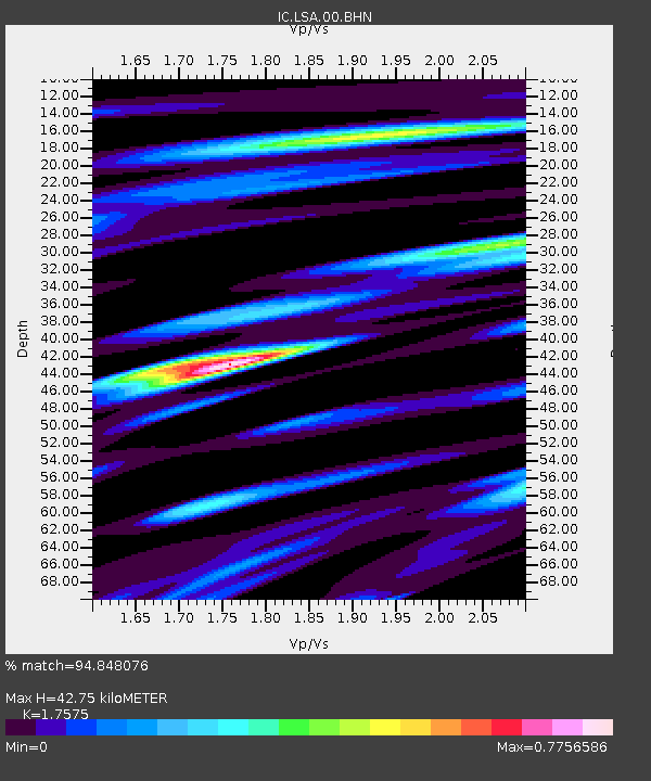
| Estimated Moho Depth: |
42.75 km |
| Estimated Crust Vp/Vs: |
1.76 |
| Assumed Crust Vp: |
6.514 km/s |
| Estimated Crust Vs: |
3.707 km/s |
| Estimated Crust Poisson's Ratio: |
0.26 |
|
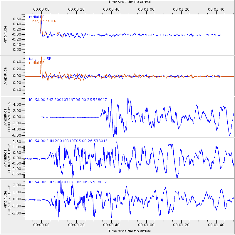
| Radial Match: |
94.848076 % |
| Radial Bump: |
400 |
| Transverse Match: |
83.80436 % |
| Transverse Bump: |
400 |
| SOD ConfigId: |
4714 |
| Insert Time: |
2010-03-04 22:40:55.458 +0000 |
| GWidth: |
2.5 |
| Max Bumps: |
400 |
| Tol: |
0.001 |
|
Signal To Noise
| Channel | StoN | STA | LTA |
| IC:LSA:00:BHN:20010319T06:00:26.53801Z | 5.237416 | 1.2663939E-7 | 2.4179748E-8 |
| IC:LSA:00:BHE:20010319T06:00:26.53801Z | 4.058877 | 1.6006773E-7 | 3.9436454E-8 |
| IC:LSA:00:BHZ:20010319T06:00:26.53801Z | 6.9722505 | 5.2518044E-7 | 7.532438E-8 |
| Arrivals |
| Ps | 5.3 SECOND |
| PpPs | 17 SECOND |
| PsPs/PpSs | 22 SECOND |


