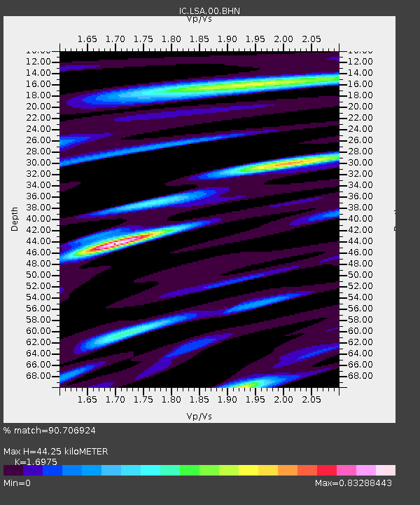
LSA Tibet, China - Earthquake Result Viewer
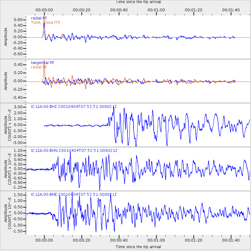
Earthquake location: Aru Islands Region, Indonesia
Earthquake latitude/longitude: -5.2/132.4
Earthquake time(UTC): 2001/04/04 (094) 07:44:11 GMT
Earthquake Depth: 33 km
Earthquake Magnitude: 5.9 MB, 6.0 MS, 6.4 MW, 6.4 MW
Earthquake Catalog/Contributor: WHDF/NEIC
Network: IC New China Digital Seismograph Network
Station: LSA Tibet, China
Lat/Lon: 29.70 N/91.15 E
Elevation: 3789 m
Distance: 52.6 deg
Az: 313.791 deg
Baz: 124.275 deg
Ray Param: 0.06660774
Estimated Moho Depth: 44.25 km
Estimated Crust Vp/Vs: 1.70
Assumed Crust Vp: 6.514 km/s
Estimated Crust Vs: 3.838 km/s
Estimated Crust Poisson's Ratio: 0.23
Radial Match: 90.706924 %
Radial Bump: 400
Transverse Match: 82.34296 %
Transverse Bump: 400
SOD ConfigId: 4714
Insert Time: 2010-03-04 22:40:57.307 +0000
GWidth: 2.5
Max Bumps: 400
Tol: 0.001

Signal To Noise

ChannelStoNSTALTA
IC:LSA:00:BHN:20010404T07:52:51.009021Z3.82205378.834238E-82.3113854E-8
IC:LSA:00:BHE:20010404T07:52:51.009021Z3.50187441.3640341E-73.8951548E-8
IC:LSA:00:BHZ:20010404T07:52:51.009021Z5.52851723.4739097E-76.2836186E-8
Arrivals
Ps5.0 SECOND
PpPs17 SECOND
PsPs/PpSs22 SECOND