You are here: Home > Network List > AF - Africa Array Stations List
> Station DODT Dodoma, Tanzania > Earthquake Result Viewer
DODT Dodoma, Tanzania - Earthquake Result Viewer
| Earthquake location: |
Banda Sea |
| Earthquake latitude/longitude: |
-4.1/129.5 |
| Earthquake time(UTC): |
2015/12/09 (343) 10:21:50 GMT |
| Earthquake Depth: |
34 km |
| Earthquake Magnitude: |
6.9 MWP |
| Earthquake Catalog/Contributor: |
NEIC PDE/NEIC COMCAT |
|
| Network: |
AF Africa Array |
| Station: |
DODT Dodoma, Tanzania |
| Lat/Lon: |
6.19 S/35.75 E |
| Elevation: |
1114 m |
|
| Distance: |
93.3 deg |
| Az: |
263.594 deg |
| Baz: |
94.473 deg |
| Ray Param: |
0.041284494 |
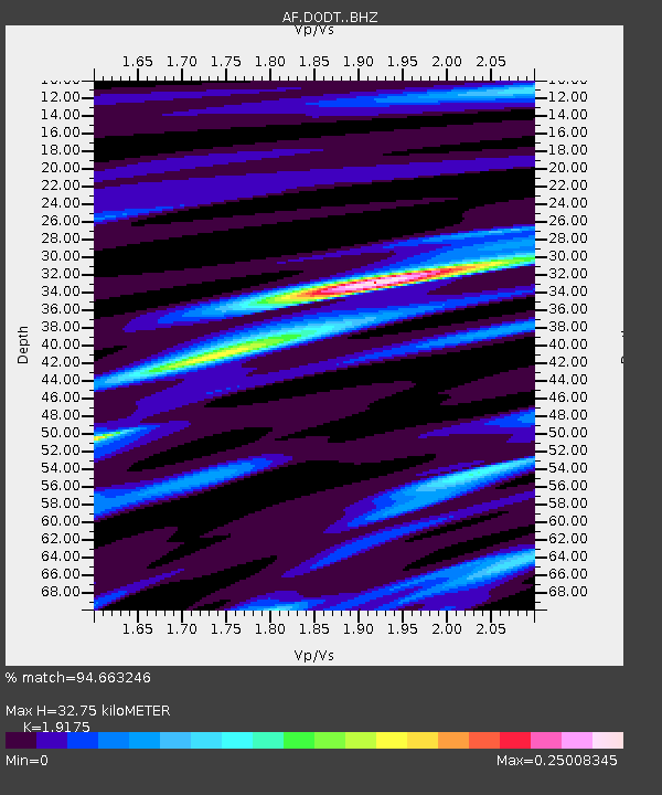
| Estimated Moho Depth: |
32.75 km |
| Estimated Crust Vp/Vs: |
1.92 |
| Assumed Crust Vp: |
6.65 km/s |
| Estimated Crust Vs: |
3.468 km/s |
| Estimated Crust Poisson's Ratio: |
0.31 |
|
| Radial Match: |
94.663246 % |
| Radial Bump: |
400 |
| Transverse Match: |
84.816185 % |
| Transverse Bump: |
400 |
| SOD ConfigId: |
7422571 |
| Insert Time: |
2019-04-21 14:06:03.161 +0000 |
| GWidth: |
2.5 |
| Max Bumps: |
400 |
| Tol: |
0.001 |
|

Signal To Noise
| Channel | StoN | STA | LTA |
| AF:DODT: :BHZ:20151209T10:34:30.05501Z | 28.5598 | 9.825197E-13 | 3.4402192E-14 |
| AF:DODT: :BHN:20151209T10:34:30.05501Z | 2.882488 | 3.9942753E-14 | 1.38570414E-14 |
| AF:DODT: :BHE:20151209T10:34:30.05501Z | 10.039532 | 9.7541956E-14 | 9.715787E-15 |
| Arrivals |
| Ps | 4.6 SECOND |
| PpPs | 14 SECOND |
| PsPs/PpSs | 19 SECOND |


