You are here: Home > Network List > CI - Caltech Regional Seismic Network Stations List
> Station VES Vestal, Porterville, CA, USA > Earthquake Result Viewer
VES Vestal, Porterville, CA, USA - Earthquake Result Viewer
| Earthquake location: |
Hokkaido, Japan Region |
| Earthquake latitude/longitude: |
42.9/145.2 |
| Earthquake time(UTC): |
2004/12/06 (341) 14:15:11 GMT |
| Earthquake Depth: |
35 km |
| Earthquake Magnitude: |
6.5 MB, 6.5 MS, 6.8 MW, 6.8 MW |
| Earthquake Catalog/Contributor: |
WHDF/NEIC |
|
| Network: |
CI Caltech Regional Seismic Network |
| Station: |
VES Vestal, Porterville, CA, USA |
| Lat/Lon: |
35.84 N/119.08 W |
| Elevation: |
154 m |
|
| Distance: |
70.4 deg |
| Az: |
59.147 deg |
| Baz: |
309.068 deg |
| Ray Param: |
0.054984808 |
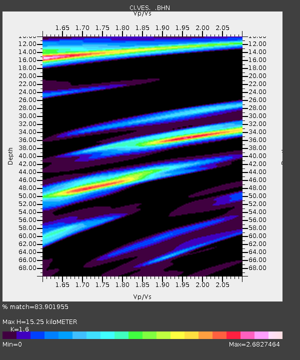
| Estimated Moho Depth: |
15.25 km |
| Estimated Crust Vp/Vs: |
1.60 |
| Assumed Crust Vp: |
6.1 km/s |
| Estimated Crust Vs: |
3.812 km/s |
| Estimated Crust Poisson's Ratio: |
0.18 |
|
| Radial Match: |
83.901955 % |
| Radial Bump: |
400 |
| Transverse Match: |
80.038605 % |
| Transverse Bump: |
400 |
| SOD ConfigId: |
2459 |
| Insert Time: |
2010-02-26 00:00:38.407 +0000 |
| GWidth: |
2.5 |
| Max Bumps: |
400 |
| Tol: |
0.001 |
|

Signal To Noise
| Channel | StoN | STA | LTA |
| CI:VES: :BHN:20041206T14:25:51.205002Z | 1.1690978 | 1.2028893E-6 | 1.0289039E-6 |
| CI:VES: :BHE:20041206T14:25:51.205002Z | 3.601987 | 2.9273565E-6 | 8.1270605E-7 |
| CI:VES: :BHZ:20041206T14:25:51.205002Z | 8.693988 | 2.804343E-6 | 3.2256116E-7 |
| Arrivals |
| Ps | 1.6 SECOND |
| PpPs | 6.3 SECOND |
| PsPs/PpSs | 7.8 SECOND |


