You are here: Home > Network List > CN - Canadian National Seismograph Network Stations List
> Station INK INUVIK, NT > Earthquake Result Viewer
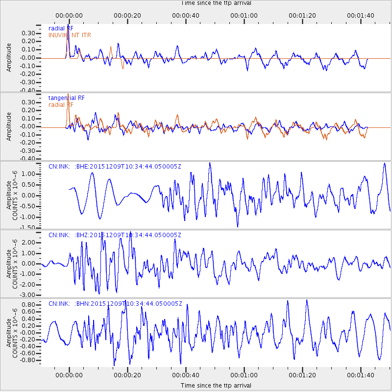
INK INUVIK, NT - Earthquake Result Viewer
*The percent match for this event was below the threshold and hence no stack was calculated.
| Earthquake location: |
Banda Sea |
| Earthquake latitude/longitude: |
-4.1/129.5 |
| Earthquake time(UTC): |
2015/12/09 (343) 10:21:50 GMT |
| Earthquake Depth: |
34 km |
| Earthquake Magnitude: |
6.9 MWP |
| Earthquake Catalog/Contributor: |
NEIC PDE/NEIC COMCAT |
|
| Network: |
CN Canadian National Seismograph Network |
| Station: |
INK INUVIK, NT |
| Lat/Lon: |
68.31 N/133.53 W |
| Elevation: |
44 m |
|
| Distance: |
96.4 deg |
| Az: |
21.798 deg |
| Baz: |
274.98 deg |
| Ray Param: |
$rayparam |
*The percent match for this event was below the threshold and hence was not used in the summary stack. |
|
| Radial Match: |
71.36576 % |
| Radial Bump: |
400 |
| Transverse Match: |
74.66991 % |
| Transverse Bump: |
400 |
| SOD ConfigId: |
7422571 |
| Insert Time: |
2019-04-21 14:07:18.750 +0000 |
| GWidth: |
2.5 |
| Max Bumps: |
400 |
| Tol: |
0.001 |
|
Signal To Noise
| Channel | StoN | STA | LTA |
| CN:INK: :BHZ:20151209T10:34:44.050005Z | 3.8394494 | 9.357694E-7 | 2.437249E-7 |
| CN:INK: :BHN:20151209T10:34:44.050005Z | 0.8121376 | 2.5093993E-7 | 3.0898698E-7 |
| CN:INK: :BHE:20151209T10:34:44.050005Z | 0.73990035 | 3.64287E-7 | 4.9234603E-7 |
| Arrivals |
| Ps | |
| PpPs | |
| PsPs/PpSs | |


