You are here: Home > Network List > IC - New China Digital Seismograph Network Stations List
> Station LSA Tibet, China > Earthquake Result Viewer
LSA Tibet, China - Earthquake Result Viewer
| Earthquake location: |
Sumbawa Region, Indonesia |
| Earthquake latitude/longitude: |
-8.7/117.0 |
| Earthquake time(UTC): |
1997/10/23 (296) 01:16:01 GMT |
| Earthquake Depth: |
160 km |
| Earthquake Magnitude: |
5.5 MB |
| Earthquake Catalog/Contributor: |
WHDF/NEIC |
|
| Network: |
IC New China Digital Seismograph Network |
| Station: |
LSA Tibet, China |
| Lat/Lon: |
29.70 N/91.15 E |
| Elevation: |
3789 m |
|
| Distance: |
45.6 deg |
| Az: |
327.877 deg |
| Baz: |
142.824 deg |
| Ray Param: |
0.070623495 |
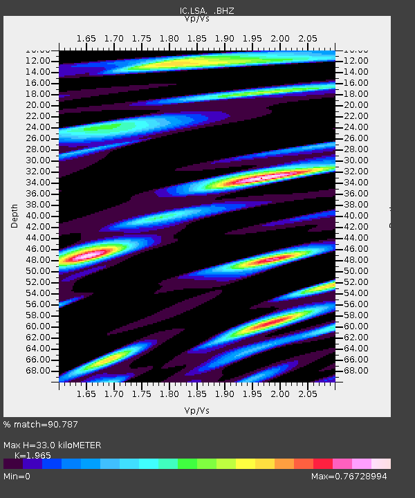
| Estimated Moho Depth: |
33.0 km |
| Estimated Crust Vp/Vs: |
1.97 |
| Assumed Crust Vp: |
6.514 km/s |
| Estimated Crust Vs: |
3.315 km/s |
| Estimated Crust Poisson's Ratio: |
0.33 |
|
| Radial Match: |
90.787 % |
| Radial Bump: |
400 |
| Transverse Match: |
77.08071 % |
| Transverse Bump: |
400 |
| SOD ConfigId: |
4480 |
| Insert Time: |
2010-03-04 22:41:29.977 +0000 |
| GWidth: |
2.5 |
| Max Bumps: |
400 |
| Tol: |
0.001 |
|
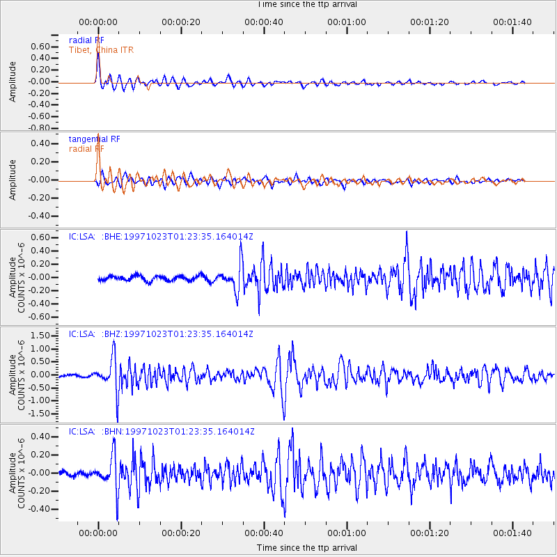
Signal To Noise
| Channel | StoN | STA | LTA |
| IC:LSA: :BHZ:19971023T01:23:35.164014Z | 15.0164 | 6.621341E-7 | 4.409406E-8 |
| IC:LSA: :BHN:19971023T01:23:35.164014Z | 7.760809 | 1.9206533E-7 | 2.4748108E-8 |
| IC:LSA: :BHE:19971023T01:23:35.164014Z | 5.6630745 | 2.016445E-7 | 3.5606895E-8 |
| Arrivals |
| Ps | 5.2 SECOND |
| PpPs | 14 SECOND |
| PsPs/PpSs | 19 SECOND |


