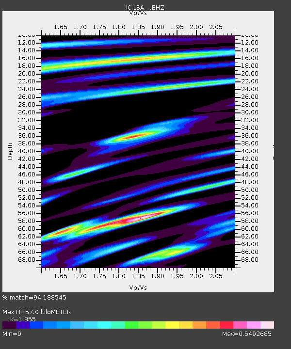
LSA Tibet, China - Earthquake Result Viewer
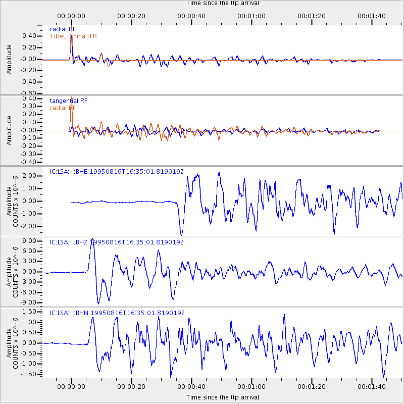
Earthquake location: New Ireland Region, P.N.G.
Earthquake latitude/longitude: -5.4/153.8
Earthquake time(UTC): 1995/08/16 (228) 16:24:26 GMT
Earthquake Depth: 21 km
Earthquake Magnitude: 5.6 MB, 6.8 MS, 6.8 UNKNOWN, 6.6 MW
Earthquake Catalog/Contributor: WHDF/NEIC
Network: IC New China Digital Seismograph Network
Station: LSA Tibet, China
Lat/Lon: 29.70 N/91.15 E
Elevation: 3789 m
Distance: 69.4 deg
Az: 304.366 deg
Baz: 109.171 deg
Ray Param: 0.05566439
Estimated Moho Depth: 57.0 km
Estimated Crust Vp/Vs: 1.86
Assumed Crust Vp: 6.514 km/s
Estimated Crust Vs: 3.512 km/s
Estimated Crust Poisson's Ratio: 0.30
Radial Match: 94.188545 %
Radial Bump: 400
Transverse Match: 88.32207 %
Transverse Bump: 400
SOD ConfigId: 4480
Insert Time: 2010-03-04 22:41:32.766 +0000
GWidth: 2.5
Max Bumps: 400
Tol: 0.001

Signal To Noise

ChannelStoNSTALTA
IC:LSA: :BHZ:19950816T16:35:01.819019Z1.90593721.8372764E-79.639753E-8
IC:LSA: :BHN:19950816T16:35:01.819019Z0.435531171.7265348E-83.964205E-8
IC:LSA: :BHE:19950816T16:35:01.819019Z0.87076924.5069413E-85.1758164E-8
Arrivals
Ps7.8 SECOND
PpPs24 SECOND
PsPs/PpSs32 SECOND