You are here: Home > Network List > S - Seismographs in Schools Projects Stations List
> Station AUUHS Ulladulla High School, Ulladulla, NSW > Earthquake Result Viewer
AUUHS Ulladulla High School, Ulladulla, NSW - Earthquake Result Viewer
| Earthquake location: |
Banda Sea |
| Earthquake latitude/longitude: |
-4.1/129.5 |
| Earthquake time(UTC): |
2015/12/09 (343) 10:21:50 GMT |
| Earthquake Depth: |
34 km |
| Earthquake Magnitude: |
6.9 MWP |
| Earthquake Catalog/Contributor: |
NEIC PDE/NEIC COMCAT |
|
| Network: |
S Seismographs in Schools Projects |
| Station: |
AUUHS Ulladulla High School, Ulladulla, NSW |
| Lat/Lon: |
35.36 S/150.47 E |
| Elevation: |
44 m |
|
| Distance: |
36.7 deg |
| Az: |
150.626 deg |
| Baz: |
323.232 deg |
| Ray Param: |
0.076500215 |
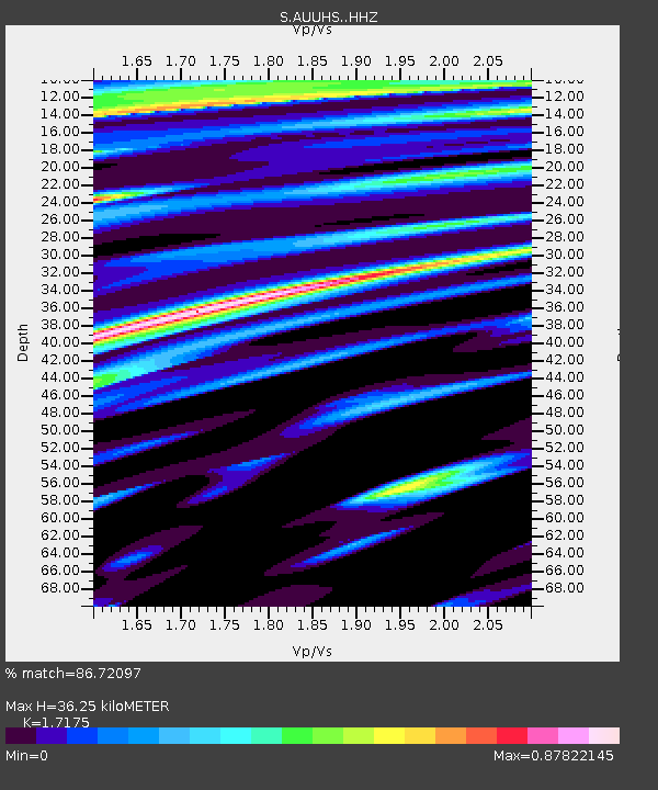
| Estimated Moho Depth: |
36.25 km |
| Estimated Crust Vp/Vs: |
1.72 |
| Assumed Crust Vp: |
6.472 km/s |
| Estimated Crust Vs: |
3.768 km/s |
| Estimated Crust Poisson's Ratio: |
0.24 |
|
| Radial Match: |
86.72097 % |
| Radial Bump: |
400 |
| Transverse Match: |
58.16431 % |
| Transverse Bump: |
400 |
| SOD ConfigId: |
7422571 |
| Insert Time: |
2019-04-21 14:09:02.545 +0000 |
| GWidth: |
2.5 |
| Max Bumps: |
400 |
| Tol: |
0.001 |
|

Signal To Noise
| Channel | StoN | STA | LTA |
| S:AUUHS: :HHZ:20151209T10:28:22.789995Z | 5.7704816 | 4.874979E-6 | 8.4481314E-7 |
| S:AUUHS: :HHN:20151209T10:28:22.789995Z | 3.506004 | 1.9072605E-6 | 5.4399834E-7 |
| S:AUUHS: :HHE:20151209T10:28:22.789995Z | 1.415554 | 2.660409E-6 | 1.879412E-6 |
| Arrivals |
| Ps | 4.3 SECOND |
| PpPs | 14 SECOND |
| PsPs/PpSs | 18 SECOND |


