You are here: Home > Network List > TA - USArray Transportable Network (new EarthScope stations) Stations List
> Station H24K Noodor Dome, AK, USA > Earthquake Result Viewer
H24K Noodor Dome, AK, USA - Earthquake Result Viewer
| Earthquake location: |
Banda Sea |
| Earthquake latitude/longitude: |
-4.1/129.5 |
| Earthquake time(UTC): |
2015/12/09 (343) 10:21:50 GMT |
| Earthquake Depth: |
34 km |
| Earthquake Magnitude: |
6.9 MWP |
| Earthquake Catalog/Contributor: |
NEIC PDE/NEIC COMCAT |
|
| Network: |
TA USArray Transportable Network (new EarthScope stations) |
| Station: |
H24K Noodor Dome, AK, USA |
| Lat/Lon: |
65.84 N/147.88 W |
| Elevation: |
814 m |
|
| Distance: |
90.7 deg |
| Az: |
24.096 deg |
| Baz: |
261.619 deg |
| Ray Param: |
0.04164962 |
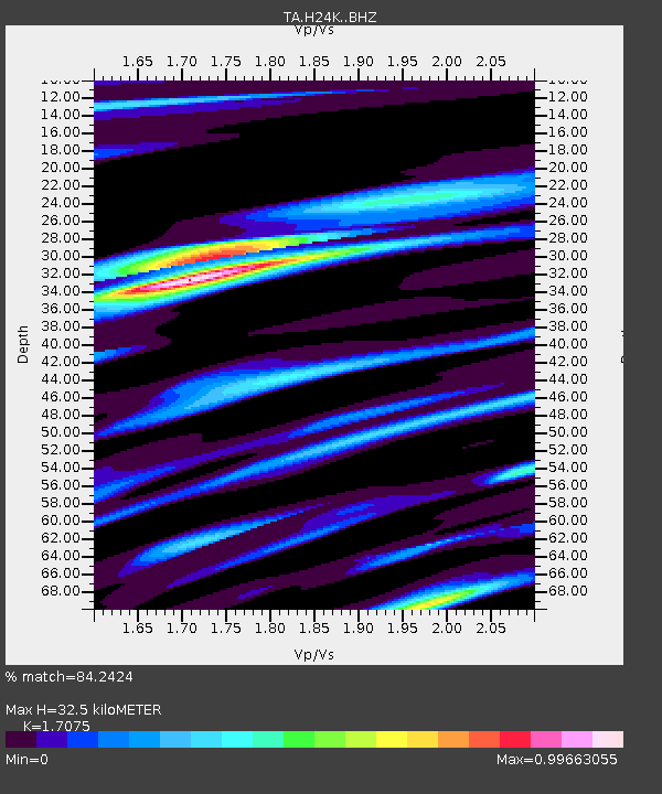
| Estimated Moho Depth: |
32.5 km |
| Estimated Crust Vp/Vs: |
1.71 |
| Assumed Crust Vp: |
6.566 km/s |
| Estimated Crust Vs: |
3.845 km/s |
| Estimated Crust Poisson's Ratio: |
0.24 |
|
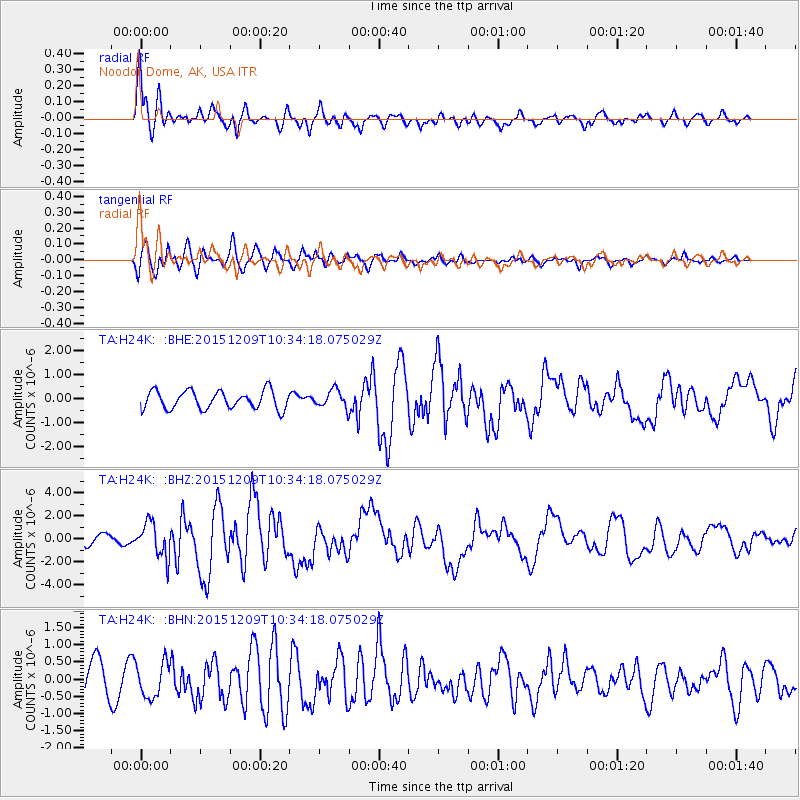
| Radial Match: |
84.2424 % |
| Radial Bump: |
400 |
| Transverse Match: |
64.49046 % |
| Transverse Bump: |
400 |
| SOD ConfigId: |
7422571 |
| Insert Time: |
2019-04-21 14:09:06.583 +0000 |
| GWidth: |
2.5 |
| Max Bumps: |
400 |
| Tol: |
0.001 |
|
Signal To Noise
| Channel | StoN | STA | LTA |
| TA:H24K: :BHZ:20151209T10:34:18.075029Z | 3.3970504 | 1.4887677E-6 | 4.3825307E-7 |
| TA:H24K: :BHN:20151209T10:34:18.075029Z | 1.0439438 | 5.026411E-7 | 4.814829E-7 |
| TA:H24K: :BHE:20151209T10:34:18.075029Z | 1.0619631 | 3.9162515E-7 | 3.6877472E-7 |
| Arrivals |
| Ps | 3.6 SECOND |
| PpPs | 13 SECOND |
| PsPs/PpSs | 17 SECOND |


