You are here: Home > Network List > TA - USArray Transportable Network (new EarthScope stations) Stations List
> Station K20K Telida, AK, USA > Earthquake Result Viewer
K20K Telida, AK, USA - Earthquake Result Viewer
| Earthquake location: |
Banda Sea |
| Earthquake latitude/longitude: |
-4.1/129.5 |
| Earthquake time(UTC): |
2015/12/09 (343) 10:21:50 GMT |
| Earthquake Depth: |
34 km |
| Earthquake Magnitude: |
6.9 MWP |
| Earthquake Catalog/Contributor: |
NEIC PDE/NEIC COMCAT |
|
| Network: |
TA USArray Transportable Network (new EarthScope stations) |
| Station: |
K20K Telida, AK, USA |
| Lat/Lon: |
63.36 N/154.07 W |
| Elevation: |
548 m |
|
| Distance: |
87.6 deg |
| Az: |
26.02 deg |
| Baz: |
256.058 deg |
| Ray Param: |
0.04315595 |
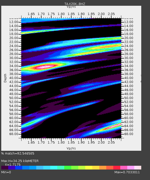
| Estimated Moho Depth: |
34.25 km |
| Estimated Crust Vp/Vs: |
1.72 |
| Assumed Crust Vp: |
6.438 km/s |
| Estimated Crust Vs: |
3.749 km/s |
| Estimated Crust Poisson's Ratio: |
0.24 |
|
| Radial Match: |
92.546585 % |
| Radial Bump: |
352 |
| Transverse Match: |
82.22907 % |
| Transverse Bump: |
400 |
| SOD ConfigId: |
7422571 |
| Insert Time: |
2019-04-21 14:09:10.272 +0000 |
| GWidth: |
2.5 |
| Max Bumps: |
400 |
| Tol: |
0.001 |
|

Signal To Noise
| Channel | StoN | STA | LTA |
| TA:K20K: :BHZ:20151209T10:34:03.52498Z | 4.528629 | 1.559132E-6 | 3.4428345E-7 |
| TA:K20K: :BHN:20151209T10:34:03.52498Z | 0.45015433 | 2.7352462E-7 | 6.076241E-7 |
| TA:K20K: :BHE:20151209T10:34:03.52498Z | 2.175635 | 6.161296E-7 | 2.8319528E-7 |
| Arrivals |
| Ps | 3.9 SECOND |
| PpPs | 14 SECOND |
| PsPs/PpSs | 18 SECOND |


